


- 2:40 h
- 9.27 km
- 170 m
- 170 m
- 1,237 m
- 1,401 m
- 164 m
- Start: Lauenen, Rohrbrücke
- Destination: Lauenen, Rohrbrücke
From the post bus stop Rohrbrücke in Lauenen, three hiking trails lead to the Lauenensee. We choose the path through the valley floor, along the Louwibach and via Rohr to the Lauenensee. After only a few meters, the Rohr nature reserve appears. Every year, the reed is mowed there and built into so-called Tristen. Following the Louwibach further, the gnarly forest, known as Rohröy, is crossed. At the far end of the valley floor, the ascent to the Lauenensee begins. Wooden sculptures line the hiking path and ensure that the 120 meters of altitude are quickly overcome.
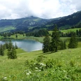
Suddenly it lies before us, the well-known and unspoiled mountain lake. A visit is appealing at every season. Accordingly, you will always meet someone here. We circle the lake counterclockwise and finally arrive at the wonderfully located restaurant.
The return route goes via the post bus stop at Legerlibrügg. Shortly thereafter, turn left and descend through the Rossfalleschlucht into the valley floor. The path to the Rohrbrücke stop is now the same as the way in: always along the Louwibach.

Good to know
Pavements
Best to visit
Equipment
We recommend the following equipment: lightweight hiking shoes, light backpack, sun protection, rain jacket, pocket first aid kit, light picnic, sufficient fluids, mobile phone.
Directions & Parking facilities
By car to Lauenen, parking lot Rohrbrücke / Alpenland
Outbound: by train via Zweisimmen to Gstaad. Then by post bus to Lauenen stop Rohrbrücke.
Return: from Lauenen Rohrbrücke to Gstaad.
Additional information
Association Bernese Hiking Trails, Bern, Tel.: 031 340 01 01, Email: info@beww.ch, Homepage: www.bernerwanderwege.ch
Literature
Hiking suggestion from the free brochure Hiking by the Water, by the Bernese Hiking Trails.
License (master data)
Safety guidelines
This route runs exclusively on marked trails categorized as hiking paths.
Map
Swisstopo hiking map 263T Wildstrubel 1:50,000
Nearby