- 5:10 h
- 12.50 km
- 1,260 m
- 540 m
- 782 m
- 1,958 m
- 1,176 m
- Start: Weissenburg
- Destination: Gurnigel/Lower Gantrisch Hut
The start is at the charming Weissenburg station. With the fountain house, where you can enjoy water from the once famous Weissenburg springs, it forms a nice ensemble from the last century turn. We stroll leisurely on the little road through the natural forest and take note of the artistically constructed dry stone walls, which were elaborately restored in 2013. On the site of the former grand hotel, we let this impressive place, which was a meeting point for the high nobility during the spa culture period and well known throughout Europe, take effect on us. The Weissenburg bathing association and its volunteers take care of the maintenance of the area and the rest area and have created an information pavilion here about the eventful spa history in the Simmental.
Here the Via Casea and the Obersimmental house trail cross. Smaller circular hikes are therefore possible if there is still snow in higher regions.
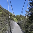
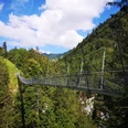
We now dive deeper and deeper into the gorge; nature and landscape become more dramatic. We suddenly come across the ruins of the Hintere Bad, restored in 2014 and 2015, and are amazed by the daring of the entrepreneurs who ran a spa hotel here 150 years ago. We cross the Morgetenbach on a small suspension bridge. Over several stairs and a secured path we reach the Leiternweide and cross the gorge of the Morgetenbach on the impressive suspension bridge. And again we are amazed: Around 1850, the Bunschental was inhabited year-round by 60 people. And the path we have come behind on the secured facility was, with only wobbly wooden ladders, used by children as a strenuous and not unhazardous school route to the valley.
A path variant offered here is the cave path, which leads to the prehistoric caves and to Oberwil.
Back to the Leitern bridge: The wide path winds ever higher through the Morgeten valley. First, the 80-meter high waterfall lies in the background. After a few bends, we stand at the top and watch how the water plunges over the edge. On the left we see impressive rock formations. Geologists rave here, because we are at a key location where rocks from very different eras become visible in a small space. The path leads over the Undriste Morgete Alp to the Mittliste Morgeten Alp. Here you can stop off excellently and also spend the night. The Haueter families rely on high-quality products from their own alpine production and organic products from the region.
From the Morgeten Alp the Via Casea leads to the Morgeten pass and further into the Gantrisch Nature Park. Our hike can also be continued to the Leitern pass or towards Stockhorn. The Morgeten Alp thus offers itself as a starting point for rewarding circular routes or pass hikes.

Good to know
Pavements
Best to visit
Directions
Weissenburg - Leiternweid - Undrist Morgete - Morgetepass - Gantrischseeli - Lower Gantrisch Hut
Equipment
We recommend the following equipment: solid mountain boots, medium-sized backpack with hip belt, sun protection, rainwear, trekking poles, pocket pharmacy, picnic, sufficient fluids, mobile phone.
Directions & Parking facilities
Return: from Oberwil i.S. or Weissenburg
For pass and circular hikes also post bus in the Gantrisch area or Stockhorn cable car
Additional information
Bernese Hiking Trails Association, Bern, Tel.: 031 340 01 01, E-mail: info@beww.ch, Homepage: www.bernerwanderwege.ch
Literature
Hiking suggestion from the Simmental - Saanenland hiking book, hiking book series of the Bernese Hiking Trails
License (master data)
Author´s Tip / Recommendation of the author
Refreshments: Alp Morgeten, Valley Tel. +41(0)33 783 18 76, Alp Tel. +41(0)33 783 18 49, Open from the end of May to the end of September
Safety guidelines
This route runs entirely or partly on mountain hiking trails.
Map
Swisstopo hiking map 1:50,000 253T Gantrisch
Nearby