


- 6:50 h
- 20.81 km
- 1,160 m
- 1,130 m
- 993 m
- 2,006 m
- 1,013 m
- Start: St. Stephan
- Destination: Matten
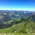
From the St. Stephan station up to the main street and on the sidewalk to the left into the village Grodei. Then keep uphill through the Bifang. On the left and right of the path stand several Simmental houses that deserve our attention. Along the ditch steeply uphill through the Gandbode forest. Then the first scenic terrace above Gfellweideni is reached with a gentler ascent. Now almost level on a soft meadow path to the Dachbode (30 min to Färmeltal/Stalde). Magnificent view into the Lenker valley floor, into the Wildstrubel-Wildhorn area, upstream into the Färmeltal, and to the nearby rocks of the Spillgerte group.
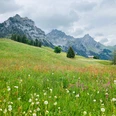
A narrow hillside path now runs almost horizontally through spruce stands, debris cones, and wide avalanche tracks. For the attentive hiker there is much to discover here: orchids in the rock debris, Apollo butterflies in the warm updraft, and sometimes venomous asp vipers right on the path! Rising through swampy pasture terrain to the Alp Am undere Bluttlig. Here again there is the option to shorten the quite strenuous tour (45 min to Büel–Stalde). The path now steeply climbs towards Grimmifurggi (pass to the Diemtigtal) up to the mountain hut Am obere Bluttlig. The effort is rewarded with a wonderful high-altitude hike through the Färmelmeder (highest point of the circular hike): Rauflihorn, Türmlihore, Gsür, and Albristhorn impressively enclose the valley basin of the Färmelberg. Over the Alp Muri and through forest it goes steeply down to the valley floor, which is reached at the Färmelläger. Now follows an extraordinarily peaceful, about two-hour valley hike off the road. Over meadows and through forest you follow the wild Färmelbach. Passing Gruebe, Büel, Stalde, and willow groves it goes steeply down to Mattehalte (45 min to St. Stephan), where there is the option to descend in a few minutes to the Matten station. A marked hiking trail also allows the indefatigable to return on foot to St. Stephan.

Good to know
Pavements
Best to visit
Directions
Equipment
Directions & Parking facilities
Outbound: By train via Spiez and Zweisimmen to St. Stephan.
Return: By train from Matten near St. Stephan to Zweisimmen
Additional information
Literature
Hiking suggestion from the Bernerland hiking book, hiking book series of the Berner Wanderwege
License (master data)
Safety guidelines
This route runs entirely or partially on signposted paths of the mountain hiking trail category.
Map
Swisstopo hiking map 1:50,000 263T Wildstrubel
Nearby
