


- 3:30 h
- 10.16 km
- 620 m
- 650 m
- 993 m
- 1,587 m
- 594 m
- Start: Matten
- Destination: St. Stephan
Time seems to have stood still in the Färmeltal. Because there is sometimes considerable avalanche danger here in winter, the valley has remained untouched by any tourist development to this day and is therefore largely intact.
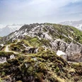
From the Matten station, head village-wards and after crossing the Färmelbach, climb uphill along the slope. Shortly after the hiking route branches off from the road, the opposite side of the Färmelbach is crossed again. Following the stream, you now go upward through pleasantly shady mountain forest. At Bachweiden, the hiking route joins the road but soon branches off again. Along the way, the sulfur spring deserves attention, unmistakably announcing its mineral content to the nose. At Stalde, the path becomes a bit steeper and more exposed to the sun. On the south slope, it first goes over meadows, later through forest thinned by storms, up to the Dachbode. In June, mountain meadows adorned with countless flowers in all colors greet you here. This view is crowned by a delightful panorama: to the east, the idyllic Färmeltal can be overlooked, to the north, the wildly eroded peaks of the Spillgerte massif offer a fascinating sight, and towards the west and south, the upper Simmental shows its loveliest side.
Now it goes downhill: first over fragrant meadows and pastures, then on an alpine road, but soon again on a narrow forest path. From the Gandbodewald, you follow the Zälgbach stream down to the Grodey district of the municipality of St. Stephan and finally to the St. Stephan station.

Good to know
Pavements
Best to visit
Directions
Equipment
Directions & Parking facilities
Outbound: by train via Spiez and Zweisimmen to Matten near St. Stephan
Return: from St. Stephan by train to Zweisimmen
Additional information
License (master data)
Safety guidelines
Map
Swisstopo hiking map 1:50,000 263T Wildstrubel
Nearby
