- 4:30 h
- 11.81 km
- 500 m
- 1,330 m
- 907 m
- 2,148 m
- 1,241 m
- Start: Obersteinberg
- Destination: Stechelberg
The nostalgic mountain hotel Obersteinberg still conveys hospitality like in grandmother's times. Even electricity has not yet been introduced. There is hardly anything cozier than strengthening yourself in a cozy guest room before a promising hiking day and admiring the awakening nature (to Pfäffer–Gimmelwald 2h10, Pfäffer–Stechelberg 1h15; to Trachsellauenen–Stechelberg 1h40).
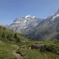
At first, it goes inland. On a rather shaky bridge, you cross the Tschingel Lütschine in Schafläger (to Trachsellauenen–Stechelberg 2h) and enter a true mountain fairytale world: dwarf birches and spruces crouch on lichen-covered boulders, between them small streams flow with miniature waterfalls. Alpine flowers shine in the short grass meadows, and marmots whistle all around. A slippery path leads over a moraine ridge up to Oberhornsee. Suddenly, it lies ahead: a blue-green eye in the mountain landscape, surrounded by white fluffy cotton grass and crowned by glacier ice and rock spikes.
The beautiful alpine pasture on both sides of the nearby Chrummbach forms a soothing contrast to all the rock debris and granite mounds surrounding the lake. Following the creek, you now briefly head downstream. In front of the alpine hut, the path already goes back uphill. After crossing the Oberhorn moraine and the Schmadribach, at point 2111 you reach the junction to the Schmadri hut (ascent to the hut 30 min). Crossing more scree fields and following rock ledges, you descend steeply to Tanzhubel. Here you are almost at the same altitude as at the starting point of the hike. Overwhelming is the view into the whitewater landscape at Untersteinberg. Several glacier streams have to be crossed to the goat stables in Schwand.
On a zigzag path, it finally goes even steeper down to Trachsellauenen, then off the valley path out to Stechelberg.

Good to know
Pavements
Best to visit
Directions
Obersteinberg - Schafläger - Oberhornsee - Schwand - Stechelberg
Equipment
We recommend the following equipment: sturdy mountain boots, medium-sized backpack with hip belt, sun protection, rainwear, hiking poles, first aid kit, picnic, sufficient fluids, mobile phone.
Directions & Parking facilities
Outbound and return travel: by train via Interlaken Ost to Lauterbrunnen. From there by bus to Stechelberg.
Additional information
Association Bernese Hiking Trails, Bern, Tel.: 031 340 01 01, E-Mail: info@beww.ch, Homepage: www.bernerwanderwege.ch
Literature
Hiking suggestion from the hiking book Jungfrau Region Brienzersee - Oberhasli of the Bernese Hiking Trails
License (master data)
Safety guidelines
This route runs entirely or partially on marked trails of the mountain hiking trail category.
Map
Swisstopo hiking map 1:50,000 264T Jungfrau
Nearby