


- 3:30 h
- 10.41 km
- 265 m
- 950 m
- 993 m
- 1,746 m
- 753 m
- Start: Jaunpass
- Destination: Jaun
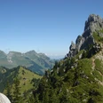
From the pass summit, the continuation of the path used to lead steeply down through the impassable Spitzenegg Gorge to the Jäunli. Today, one stays on the scenic height. In a wide arc, an alpine road leads around the Zügweg equipped with ski lifts into the swampy Bädermoos, where it splits and turns westwards around the Bäderegg. Always gently ascending, the little road now turns north into the raised moor basin of the Bäderberg, above which the cliffs of the Bäderhorn tower. Now the path leads directly to the sparsely wooded ridge and reaches the culmination point of the hike at the junction of the Bäderhorn ascent (point 1744). Magnificent is the view to the mountains of the Jauntal and to Jaun, lying 700 m lower. Also beautifully contrasting are the round, green mounds above the Abländschen Valley with the sharp rock teeth of the Gastlosen range. The descent requires some attention. First, the path gently descends through the northern flank of the Bäderhorn. After passing a landslide area, it follows this very steeply down to Ober Obfängli. From there, a forest road leads at a slight up and down incline to the little road in the Leimera, where the historic mountain pass trail from Chlus (Route 30a) joins. Like a panorama trail, the little road winds down in many hairpin bends into the Grabenweidli. In the tight curve on the forest road going downstream, keep to the path, then always close to the Oberbach down to Kappelboden at the pass road and on a footpath just below it to the village center of Jaun, whose French name, Bellegarde, refers to a watchtower.

Good to know
Pavements
Best to visit
Directions
Equipment
Directions & Parking facilities
Outbound trip: by train to Boltigen. From there by bus to Jaunpass.
Return trip: by bus from Jaun to Boltigen or Bulle
Additional information
Literature
Hiking suggestion from the hiking book Passwege in the Bernese Oberland, hiking book series of the Bernese Hiking Trails
License (master data)
Safety guidelines
Map
Swisstopo hiking map 1:50,000 253T Gantrisch
Nearby
