


- 3:00 h
- 8.23 km
- 218 m
- 218 m
- 1,504 m
- 1,671 m
- 167 m
- Start: Jaunpass
- Destination: Jaunpass
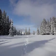
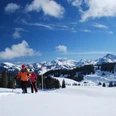
The Jaunpass connects the Simmental with the Greyerzerland, the canton of Bern with the canton of Freiburg. The pass height is at 1509 m above sea level. It is accessible by a road, the construction of which was mainly for military reasons: after the Franco-Prussian War 1870/71, it was meant to connect the military centers Thun and Bulle. The area around the pass height is not only a family ski area but also an ideal starting point for other winter sports activities such as cross-country skiing, ski touring, winter hiking – and snowshoeing. The marked Jaunpass Trail leads over snowy fields and through snow-clad fir forests south under the Bäderhorn summit. The view of the distinctive Gastlosen peaks is simply magnificent. The views into the Niedersimmental and to the Bernese Alps are also splendid. The snowshoe trail partly crosses avalanche-prone areas and can therefore sometimes be closed. The rule is: observe signage and inform yourself beforehand about current conditions.

Good to know
Pavements
Best to visit
Directions
Equipment
Directions & Parking facilities
Additional information
Tourism office Boltigen-Jaunpass, Tel. +41 (33) 773 69 19, www.boltigen.ch
Lenk-Simmental Tourism, Tel. +41 (0) 33 736 35 35, www.lenk-simmental.ch
Refreshments:
Restaurants and grocery store at Jaunpass.
Literature
Jochen Ihle / Toni Kaiser: The 66 Most Beautiful Snowshoe Routes in Switzerland. ISBN 978-3-03865-077-5, Rothus Medien, Solothurn, www.wandershop-schweiz.ch
Jochen Ihle / Toni Kaiser: The 101 Most Beautiful Winter Hikes in Switzerland (with snowshoe routes). ISBN 978-3-03865-055-3, Rothus Medien, Solothurn, www.wandershop-schweiz.ch
License (master data)
Author´s Tip / Recommendation of the author
Safety guidelines
Map
Nearby
