


- 7:00 h
- 18.38 km
- 1,280 m
- 1,280 m
- 922 m
- 1,961 m
- 1,039 m
- Start: Kiental
- Destination: Kiental
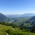
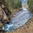
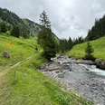
From the Kiental bus stop, head upstream and descend to the Chiene. Cross it at the chairlift valley station and gently ascend along the valley trail following the Gornerewasser to Losplatte. The hotel and Bir Alperue bus stop lie further upstream just beyond the stream, which you follow to the Tschingelsee. This lake was only formed in 1972 after a severe storm during which the valley floor was dammed with debris and mud up to 6 m high. At the very end of the Gorneregrund, the wild water trail offers eerily beautiful glimpses into the wild waters of the Griesschlucht. The so-called Hexenkessel (witches' cauldron) fully lives up to its name! On a well-constructed path, ascend to Golderli. The mountain alley towards Aabeberg continues to climb steeply. Only between Gälmli and Chollere does a short slope traverse allow a brief rest. But the ascent to the Chanzel is demanding again. Between bright limestone rocks and then over a broad grassy ridge you climb to the highest point of the Aabeberg. The panoramic view is incomparable! Especially the southern valley end with the thunderous Dündefälle waterfalls, along with Blüemlisalp and Gspaltenhorn, is unique. The descent leads back to the Chanzel and—just as steep as the ascent—zigzags down to Spiggegrund/Schwand. In the valley floor, the Spiggebach is crossed. Alternately over pastureland and through forest, you reach the Spiggeweid and from there, on a narrow path, high above the wild ravine beneath a cliff, back to Kiental.

Good to know
Pavements
Best to visit
Directions
Equipment
Directions & Parking facilities
Additional information
Literature
Hiking suggestion from the Thunersee - Frutigland hiking book, hiking book series of the BWW
License (master data)
Safety guidelines
This route runs entirely or partly on marked trails of the mountain hiking trail category.
Map
Swisstopo hiking map 1:50,000 264T Jungfrau
Nearby