
- 4:00 h
- 9.64 km
- 1,120 m
- 90 m
- 944 m
- 2,061 m
- 1,117 m
- Start: Grindelwald
- Destination: Kleine Scheidegg
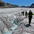
What the waterfalls are for the Lauterbrunnen Valley, the two glaciers are for Grindelwald. Until 1860, the Lower Grindelwald Glacier reached into the gardens of the first houses. However, from 1875 a worrying accelerating glacier retreat began, which has reached a record-breaking extent with a length loss of 60 m per year at the Upper Grindelwald Glacier.
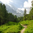
Descend from Grindelwald station near the railway line to the Grund station. On the climb beyond the bridge over the Schwarze Lütschine, small streets, driving paths, and footpaths alternate in different rhythms. The Brandegg station (3 min from the hiking trail) is bypassed in the forest. Shortly thereafter, the path changes through the underpass to the other side of the railway line. On the further ascent, the forest boundary gradually recedes and the view of the large chalet settlement Grindelwald, the Grosse Scheidegg, and the Wetterhorn becomes more and more comprehensive.
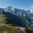
The incline between Alpiglen (starting point of the 'Eiger Trail') and Arvengarten is somewhat gentler. The north face of the Eiger rises mightily. Although 150 to 200 mountaineers climb this face each year, the fatal accidents since the first ascent in 1938 with a total of 50 victims have remained relatively limited. More and more, the rugged flanks of Mönch and Jungfrau and the prominent, perfectly shaped Silberhorn come into view. Dark larches form the picturesque foreground. Where these also recede, the pass height of Kleine Scheidegg is within reach (starting point of the Jungfrau Railway opened in 1912). The tourist hustle and bustle is linked to this transport hub.

Good to know
Pavements
Best to visit
Directions
Equipment
Directions & Parking facilities
Outbound: By train via Interlaken East to Grindelwald.
Return: From Kleine Scheidegg by train to Grindelwald and onward to Interlaken East or via Wengen and Lauterbrunnen to Interlaken East
Additional information
Literature
License (master data)
Safety guidelines
This route runs exclusively on signposted paths of the hiking trail category
Map
Nearby
")
