


- 4:50 h
- 13.02 km
- 1,007 m
- 141 m
- 1,078 m
- 2,079 m
- 1,001 m
- Start: Lenk / valley station Betelberg
- Destination: Lenk / mountain station Betelberg
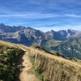
From the valley station Betelberg, the path leads up to the Hohliebe and further to the valley station Wallegg (winter operation only). Then you climb along the riverbed of the Wallbach to the Wallbach gorge. The impressive Wallbach gorge with its rock formations finely polished by water is explored on a stair-like path through the forest up to the Wallegg restaurant. From here, the Wallbach is crossed again from one side of the gorge to the other. From Lochberg, the forest opens up and the view of the Gryden area with its “Stübleni” unfolds. “Stübleni” (little rooms) refers to the individual “craters” in the Gryden area, whereby “Gryde” probably stems from Chride (chalk). As the nearly white gypsum rock slowly dissolves through rain and underground drainage, sinkholes (dolines) form side by side creating a crater landscape. From Lochberg to the Trütlisberg pass the path steadily rises. With the Trütlisberg pass the height is reached, from here a beautiful high path leads through the “Stübleni” to the destination, the Leiterli mountain station.
Warning! The path through the Stübleni (sinkholes) can cause problems for people who are not free from vertigo. On the left and right of the narrow path, the funnels drop down to 10 meters deep!

Good to know
Pavements
Best to visit
Directions
Equipment
Directions & Parking facilities
Outbound journey: By train via Zweisimmen to Lenk.
Return journey: From Betelberg with the gondola to Lenk.
Mountain railway: timetable
Additional information
License (master data)
Author´s Tip / Recommendation of the author
Operating hours gondola: timetable
Safety guidelines
After snowmelt (avoid the Wallbach gorge during prolonged rain or thunderstorms, the river can rise quickly). If in doubt, contact the tourist center.
Warning! The path through the Stübleni (sinkholes) can cause problems for people who are not free from vertigo. On the left and right of the narrow path, the funnels drop down to 10 meters deep!
Map
swisstopo hiking map 263T Wildstrubel 1:50,000
Nearby
