- 6:00 h
- 15.72 km
- 1,280 m
- 1,200 m
- 945 m
- 2,006 m
- 1,061 m
- Start: Kiental
- Destination: Aeschiried
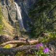
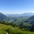
At the Kiental/Schönegg bus stop, cross the street and follow the little road that leads downhill with a slight ascent. After the Richtigraben, it goes steeply towards Hubel. Over lush meadows you continue upwards, cross an asphalt road and turn downhill again. With a gentler ascent you reach Wittere. The view back to the green Kiental towards Blüemlisalp, Ärmighorn, and Bachflue is magnificent. Climbing more steeply again, you head up to the forest. Once you reach the rock heads near the upper fir trees, you enter the wide Alp Engel. Below in the broad valley, trains roar, cars hum and people hurry. Up here there is light, tranquility, vastness, and solitude. The ascent to the Wätterlatte is partly off-path over the Standflue. Over a wide alpine ridge you head southwards higher, cross the upper forest areas on the east flank of the Standflue, and climb the clearly marked ridge Wätterlatte. The panoramic view is extensive: Above the long Sulegg stands the Wetterhorn group, and to the right rise the rugged peaks of Schreckhorn and Eiger; to the south stretches the Alpine chain visible from Blüemlisalp to the Diablerets. The descent leads steeply over the Weiderippe (not along the Flühen!). The path turns to the northeast ridge of the Wätterlatte and winds through the Flühen to the Kiental–Suldtal crossing at the Rengg. The descent to the alpine huts at Undere Obersuld is exceptionally steep. Along the alpine road, mostly through forest, you go to the mountain restaurant in Suld. At the bridge in front of the inn the path branches off through the Suldtal. In the Suldweid, you switch to the other side of the valley and reach the road leading to Aeschiried.

Good to know
Pavements
Best to visit
Directions
Kiental - Engel - Wätterlatte - Suld - Aeschiried
Equipment
We recommend the following equipment: sturdy mountain boots, medium-sized backpack with hip belt, sun protection, rainwear, hiking poles, first aid kit, picnic, sufficient fluids, mobile phone.
Directions & Parking facilities
Outbound: By train to Reichenbach. Then by bus to Kiental Ramslauenen
Return: By bus from Aeschiried, schoolhouse
Additional information
Bernese Hiking Trails Association, Bern, Tel.: 031 340 01 01, E-Mail: info@beww.ch, Homepage: www.bernerwanderwege.ch
Literature
Hiking suggestion from the hiking book Thunersee - Frutigland, hiking book series of the Bernese hiking trails.
License (master data)
Safety guidelines
This route runs entirely or partly on mountain hiking trails.
Map
Swisstopo hiking map 1:50,000 254T Interlaken
Nearby