


- 3:30 h
- 4.49 km
- 450 m
- 450 m
- 1,520 m
- 1,955 m
- 435 m
- Start: Mountain station aerial cableway Isenfluh - Sulwald
- Destination: Mountain station aerial cableway Isenfluh - Sulwald
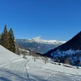
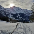
With the easy Sulwald Trail, which leads as a circular route over the Mederalp, or the somewhat more demanding Lobhorn Trail, which leads to the Lobhorn hut, there are two great snowshoe routes available. The starting and ending point of the trails is always the mountain station of the aerial cableway in Sulwald. Both trails are consistently signposted as blue and red routes. The Sulwald Trail can be safely walked with enough snow and offers a great panorama into the Jungfrau region throughout. The Lobhorn Trail should only be taken in good snow conditions or with sufficient knowledge. Attention: The Lobhorn hut is only staffed on weekends in winter!

Good to know
Best to visit
Equipment
Directions & Parking facilities
Additional information
Bernese Hiking Trails Association, Bern, Tel.: 031 340 01 01, email: info@beww.ch, homepage: www.bernerwanderwege.ch
License (master data)
Safety guidelines
Map
Nearby
