


- 1:15 h
- 2.04 km
- 170 m
- 170 m
- 1,510 m
- 1,670 m
- 160 m
- Start: Mountain station cable car Isenfluh - Sulwald
- Destination: Mountain station cable car Isenfluh - Sulwald
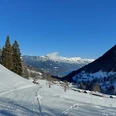
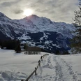
A highlight right at the start: the ride with the iconic red cable car from Isenfluh to the starting point Sulwald. Two snowshoe routes with wonderful panorama lead from Sulwald Stübli to Stutz, a little further the easier Sulwald Trail branches off to the right uphill over Bergherrenhus. Via Mederalp it goes uphill with a splendid view into the Lauterbrunnen valley and of Eiger, Mönch and Jungfrau. At the highest point Haltenmad you look into the Ahornigrabe and down into the valley. The path then goes steeply downhill over snowy meadows and leads back on the road to Sulwald Stübli. The medium-difficulty Lobhorn Trail continues from the junction to the Lobhorn hut, where there is a wonderful place to stop for food and overnight. If you like, you can inquire at the hut beforehand and have fresh groceries transported up.

Good to know
Best to visit
Directions
Sulwald – Stutz – Mederalp – Haltenmad – Sulwald
Equipment
Equipment: snowshoes, ski poles, sturdy, high, grippy and waterproof mountain or winter hiking boots, cold and sun protection, first aid kit, food and warm drinks, mobile phone, possibly gaiters
Directions & Parking facilities
Start and end point: Sulwald mountain station
by train to Lauterbrunnen, then by bus to Isenfluh / village, followed by the cable car to the starting point
Additional information
Bernese Hiking Trails, 031 340 01 01, info@beww.ch, bernerwanderwege.ch
Literature
Short brochure "Snowshoe Hiking", Bernese Hiking Trails available in our shop.
License (master data)
Author´s Tip / Recommendation of the author
Variant: Lobhorn Trail
Difficulty: medium | Fitness: medium | 4.5 km | 3 h 30 min | 450 m ascent and descent
Safety guidelines
Difficulty: medium (red) / Fitness: easy
Signposting
This route is signposted as a snowshoe trail, but not specially prepared.
Avalanches
Increased avalanche danger in spring and during sudden weather changes. Helpful but not mandatory are an avalanche transceiver (avalanche victim search device), probe and shovel. Inform yourself before the tour about snow conditions and possible avalanche hazards.
Behavior
Do not take unnecessary risks and respect your limits. Always stay on the signposted routes. Avoid wildlife if possible, behave quietly. Observe animals from a distance. Pack your rubbish back with you and leave no unwanted traces.
Map
swisstopo map: 1228 Lauterbrunnen, 1 : 25,000
Nearby
