- 5:40 h
- 9.87 km
- 1,200 m
- 1,200 m
- 739 m
- 1,835 m
- 1,096 m
- Start: Innere Urweid
- Destination: Innere Urweid
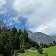
The Bänzlauistock rises steeply over Innertkirchen. On its flank, two distinctive rock towers can be seen, which rise like stone fingers into the height and are indeed called Wyler and Bottiger Daumen, after the two settlements at their foot. But this hike does not lead to these exposed peaks, but a little higher up, from where you can at least take a spectacular deep view of one of the thumbs. Before that, however, more than 1,000 meters of altitude have to be overcome. The starting point is the Innere Urweid post bus stop. On the Grimsel-Saumweg, it first goes back about half a kilometer towards Innertkirchen, then through forest and over alpine pastures to Älouwenen and from there on a varied but consistently steep forest path further to Blattenalp. Curious goats stretch their necks towards the hikers – no cow’s milk is processed on the Alp, but delicious cheese is made from pure goat’s milk. Through forest and over pastureland, partly off-trail, it continues upwards until you reach the Pfaffenchopf, a narrow rock peak sparsely covered with grass. The destination offers a magnificent panoramic view from the Gadmental in the east over the Engstlen valley and the valley floor of Meiringen to the upper Aare valley towards Grimsel. The return to the valley follows the same path.

Good to know
Pavements
Best to visit
Directions
Equipment
Additional information
License (master data)
Safety guidelines
Map
Nearby