- 0:50 h
- 1.89 km
- 201 m
- 4 m
- 3,457 m
- 3,656 m
- 199 m
- Start: Jungfraujoch - Top of Europe
- Destination: Mönchsjochhütte
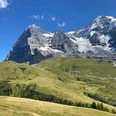
The Mönchsjochhütte is located in the heart of the UNESCO World Natural Heritage Jungfrau-Aletsch. The 4000-meter peaks such as Jungfrau, Mönch, and the Fiescherhörner are within reach, and the panoramic view into Central and Eastern Switzerland as well as the Valais Alps is almost endless! At the foot of the Mönch, the longest ice stream in Europe, the Aletsch Glacier, also begins to flow southward.
Want to discover more hikes?
Learn more about the various hiking options in the Bernese Oberland.

Interlaken Tourismus
Good to know
Best to visit
suitable
Depends on weather
Directions
Jungfraujoch-Mönchsjochhütte
Directions & Parking facilities
Paid parking available in Lauterbrunnen and Grindelwald.
Accessible from Grindelwald or Lauterbrunnen by the Wengernalpbahn and Jungfraubahn.
Additional information
Interlaken Tourism
Marktgasse 1
3800 Interlaken
Tel.: +41 33 826 53 00
mail@interlakentourism.ch
www.interlaken.ch
License (master data)
Safety guidelines
Be sure not to leave the marked path.
Nearby