
- 6:50 h
- 17.58 km
- 1,500 m
- 1,290 m
- 798 m
- 1,973 m
- 1,175 m
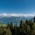
- Start: Sigriswil
- Destination: Eriz/Linden
From the village center of Sigriswil northeastwards through fertile meadows up to the terrace of Zälg and further to the large hut on Wilerallmi. Now one ascends steeply over the meadows directly towards the rock bands of the Sigriswil ridge. In the forest, the mountain path winds upwards to these. You leave the forest clearing of Chäle (gully) uphill and, after a few minutes, stand at the foot of the Spitze Flue, a popular climbing mountain.
The walk through the pasture hollow to the Unterbergli hut is relaxing. Continuing in the same direction, you now ascend through overgrown karst landscape to the signpost and the Oberbergli hut. The path more and more winds between the deeply eroded limestone rocks. Shortly after the hut, it splits. Right at the rock edge, the rock path leads over a mountain shoulder up to point 1891 at the Sigriswil Rothorn (from here, the 2051 m high eastern peak can be reached over karst fields in 30 minutes – only for experienced hikers with surefootedness!). The further path from point 1891 requires a head for heights and absolute surefootedness.
Under the vertical east and north walls of the Rothorn runs the partly exposed path of the so-called upper Rothorn ridge at the edge of a scree and grass basin to the Vorderen Schafläger. Often directly at the cliff edge, it bypasses the Mittaghorn westwards and descends over a mountain ridge past a small pond to the Hinteren Schafläger. Very steeply, one now descends through loose mountain forest to the large Oberes Hörnli hut. Over meadows and through forest, a forest road leads over Unteres Hörnli to Hornegg, which is connected to Linden in Eriz by an alpine lane over Rütegg.

Good to know
Best to visit
Directions
Equipment
Additional information
Literature
License (master data)
Safety guidelines
Map
Nearby


")
")
")