- 4:10 h
- 9.74 km
- 850 m
- 850 m
- 1,782 m
- 2,546 m
- 764 m
- Start: Elsigenalp
- Destination: Elsigenalp
From the mountain station, follow the alp road to the Elsigenalp mountain lodge and further to the Elsighütte alpine restaurant. Then ascend over alpine meadows up to the Golitschepass. From here, a first view opens towards the Kandertal valley, with the peaks of the Bernese high Alps above. Following the ridge to the right, the grassy summit of Stand is soon reached by a small curve. Continuing 300 meters along the ridge, you reach the trail junction P.2279, where the path begins the remaining 270 meters ascent to the summit of First. At a few places, the climb is narrow and surefootedness is required. From the First, a panorama opens from Lake Oeschinen over the sharp Allmegrat ridge towards Bunderspitz and the Lohner above.
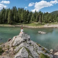
The descent to P.2279 is on the same path. At the trail junction, descend left down to the Elsigsee. It is worth planning some time to take a (swimming) break at the small mountain lake. There are also several barbecue spots near the shore. The return path to the mountain station can be taken via various routes. We recommend the beautiful nature path along the lake and down via point 1909 to the mountain lodge. Not far from there is the Brandsee, which serves for snowmaking in winter and is used as a bathing lake in summer. In a few minutes, you reach the cable car via the Elsigenalp mountain lodge.

Good to know
Pavements
Best to visit
Equipment
Additional information
Literature
Hiking book Bernese Oberland of the Bernese Hiking Trails
License (master data)
Safety guidelines
Map
swisstopo hiking map 263T Wildstrubel 1:50,000
Nearby