- 3:00 h
- 6.32 km
- 630 m
- 630 m
- 1,357 m
- 1,919 m
- 562 m
- Start: Underi Trift
- Destination: Underi Trift
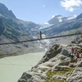
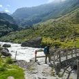
From the end of the stairs at the mountain station of the Triftbahn, go briefly to the valley floor and then continue over the bridge. On the other side, we climb up to the Bosslis Stein junction. Here we keep left and thus reach the beautifully laid out high path to the spectacular Trift Bridge. Crossing the bridge is mandatory for those without vertigo, and the beautiful view invites a picnic break. From the bridge, we ascend on the signposted Ketteliweg — as the name suggests, via a passage secured with chains — uphill. Then it continues on a flat section to the Windegg Hut, where you shouldn't miss the delicious homemade cakes. From the hut, the path leads toward the elevation marked with a flag (P.1875). From there, a steep hiking trail descends through lush greenery to the Bosslis Stein junction and on the previously described path back to the mountain station.

Good to know
Pavements
Best to visit
Equipment
Directions & Parking facilities
Arrival: by bus from Innertkirchen train station to Schwendi, Nessental Triftbahn stop
Return: by bus from Schwendi, Nessental Triftbahn stop to Innertkirchen train station
Additional information
Literature
License (master data)
Safety guidelines
Map
Nearby