- 6:15 h
- 11.89 km
- 1,217 m
- 1,517 m
- 1,050 m
- 2,566 m
- 1,516 m
- Start: Underi Trift
- Destination: Guttannen
(Alternative access) At the Furen PostBus stop, the old Susten road branches off to Gadmerwasser. At the forest edge, it goes downstream. After the next stream bridge, a steep alpine path branches uphill and climbs through the forest to Schaftelen. It leads in a wide arc, bypassing a higher situated little forest, back to Schaftellaui and climbs up along the stream. Beautiful views back to the Schwarzhorn-Wildgärst group and across the valley to Tällistock and Gadmerflue. At the fork in the path, a detour to the beautiful Gadenlaui Lake is tempting (via Hubel–Radlef to Gadenlausee 2h10; via Hubel to Gadmen 2h20). The path now descends through the forest to the Im Hori alp and crosses the Böse Graben. Deep down, the Triftwasser forces its way through the rock. Gently descending, you reach the Underi Trift mountain station of the Trift cable car in a wild rocky bowl.
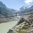
On flat path, you reach the valley floor, where you cross the stream from the wooded east to the rocky west side. The path now climbs 60 m through the mountain flank and then turns back towards the valley. The incline noticeably increases. At Bossli's Stone, the path branches left to the Trift Hut SAC, which leads over Europe's longest pedestrian suspension bridge (span 102 m, 70 m above the abyss; to the Trift Bridge 30 min, – to the Windegg Hut SAC 1h20, caution!). The white-blue-white marking beyond the bridge indicates that the way to the Trift Hut partly leads off-path over glacier and rock sections, includes small climbs, and is therefore reserved for mountaineers. But the ascent to the Windegg Hut SAC also requires some sweat. Above the hut, the path climbs steeply again and leads over the Windegg ridge into the Trift valley. From the ridge height, there is a magnificent view of the Trift Glacier, Tierberg, and Winterberg groups. In the “rocky” remote Trift valley, the path traces fade more and more. The guiding lines for the further way are the Tälliseeli, a quite prominent rock knoll in southeastern direction, and the clearly visible Furtwang saddle behind it.
Here the view suddenly opens to the upper Hasli valley and Grimsel area: a breathtaking panorama! However, there is still a descent of 1500 (!) meters in altitude to overcome until the hiking destination. On the north flank of the Rinder valley, the path goes – partly off-trail – past a mighty erratic block down to the Holzhüsalp (via Steinhüs to Guttannen 2h10). Afterward, you walk almost in the fall line over meadow and through forest – repeatedly crossing the sweeping alp road – via Farlaui–Wysstanni–Blatti down to the Sunnsyten village district and across the Aare to Guttannen.

Good to know
Pavements
Best to visit
Directions
Equipment
Additional information
Literature
License (master data)
Safety guidelines
This route runs entirely or partly on marked trails of the mountain hiking path category
Map
Nearby