


- 3:20 h
- 8.75 km
- 509 m
- 508 m
- 1,532 m
- 2,033 m
- 501 m
- Start: Gurnigel/Wasserscheidi
- Destination: Gurnigel/Wasserscheidi

Berner Wanderwege
Good to know
Pavements
Asphalt
Trail
Path
Best to visit
suitable
Depends on weather
Directions
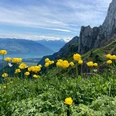
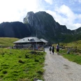
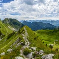
Gurnigel/Wasserscheidi - Leiteren - Morgetegrat - Gantrischseeli - Gurnigel/Wasserscheidi
Equipment
We recommend the following equipment: sturdy mountain boots, medium-sized backpack with hip belt, sun protection, rainwear, trekking poles, first aid kit, picnic, sufficient fluids.
Additional information
Bern Hiking Association, Bern, Tel.: 031 340 01 01, E-mail: info@beww.ch, Homepage: www.bernerwanderwege.ch
Literature
Hiking suggestion from the hiking book Region Bern - Gantrisch, hiking book series of the BWW, order at: http://shop.bernerwanderwege.ch
License (master data)
Safety guidelines
This route runs entirely or partly on marked paths of the mountain hiking trail category
Map
Swisstopo hiking map 1:50,000 253T Gantrisch, order at: http://shop.bernerwanderwege.ch
Nearby