- 3:40 h
- 10.54 km
- 582 m
- 581 m
- 1,042 m
- 1,574 m
- 532 m
- Start: Innereriz
- Destination: Innereriz
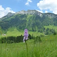
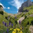
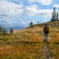
From the Innereriz post office, first descend to the Zulg bridge. Then ascend on the access road to the charming farm Dräcker. Looking back, one can see the gently curved mountain pass Sichle between Burst and Sieben Hengste. Also, the view downstream along the Zulg justifies a short stop. Now ascending quite steeply, a forest road quickly gains altitude through woods and clearings. A footpath leads through slightly swampy meadows into the wooded gully of the Chaltbach stream. A dam pathway allows crossing the following swampy terrain on dry feet, and soon the large farm Rotmoos is reached. Now begins the almost one-hour ascent under the cliffs of the Hohgant. The white-red-white color markings indicate that the ascent requires a certain mountain skill. After crossing the stream, a footpath branches off to the left from the forest road and leads over a pronounced ridge to the alpine huts of Ober Breitwang (via Chrinde to Hohgant/West summit 1h10. Caution!; to Innereriz 50 min). The view steadily widens towards Bumbach and Schrattenflue, the opposite Honegg, the valley of the Zulg, and to Burst and Sieben Hengste. Ahead towers the bastion of the Hohgant, about which Hermann Hiltbrunner says: "The limestone mass of the north face is full of wounds and scars. The mountain has something disturbing; its gaze has something of ancient sorrow." Continuing evenly up through the northwest flank, one reaches the forest at Schiltwang (to Trogenhorn 1h15, to Hohgant/West summit 1h45, caution!). Through forest and alpine pastures, the path now leads directly beneath the cliff bands and past the Arni quite rough downhill to Grünenberg and through the small valley of the Fallbach to Fall. Here cross the stream and take a good forest path to the alpine huts of Hinter Sol, shaded by mighty maples. A short but in places slippery path ends at the stream in a forest road that returns through the valley floor to Innereriz.

Good to know
Pavements
Best to visit
Directions
Equipment
Additional information
Literature
License (master data)
Author´s Tip / Recommendation of the author
Safety guidelines
Map
Nearby