- 3:15 h
- 9.44 km
- 530 m
- 60 m
- 626 m
- 1,058 m
- 432 m
- Start: Innertkirchen
- Destination: Guttannen
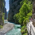
From the station or the post office in Innertkirchen, walk along the left or right bank of the Aare valley upstream. From Achistein to Boden, the route runs over the historic mule track, reactivated between 1992 and 1995 at the behest of the Inventory of Historical Traffic Routes of Switzerland (IVS) and the Bernese hiking trails in cooperation with the municipality of Innertkirchen. After Üsseri Urweid, the mule track sometimes leads almost vertically above the modern mountain pass road valleywards. At the Indri Urweid inn, the route crosses to the other riverbank on the Aare bridge rebuilt in 1995. In the rocky gorge Stocki, an inscription recalls the hard work required in 1774 to blast the path out of the rock face. Walking on carefree high above the river and the pass road. After crossing the ditch through which the Golperlaui descends, the former mule track winds through meadows scattered with partly overgrown boulders into the small village of Boden. Passing by flower-decorated old houses, you reach the pass road and cross over the old Aare bridge to the other side of the valley. Until the farmstead Under der Hoflue, the path unfortunately continues on asphalt.
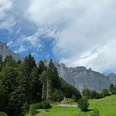
On the opposite valley side stands the former inn Ägerstein from 1820, which once served as an important customs station on the former mule track. Through boulder-strewn terrain, the path now ascends more steeply for a while and then leads over meadows to the hamlet Sunnsyten and over the bridge up to the Postplatz Guttannen. This important mountain pass location was once frequented not only by mule drivers but also by alpine herders, pilgrims, hunters, gold prospectors, and travelling merchants. Life in the village of 300 inhabitants is still tough today, as everyday life continues to be shaped by the pass road, föhn winds, and snow avalanches.

Good to know
Pavements
Best to visit
Directions
Innertkirchen - Urweid - Stocki - Boden - Guttannen
Equipment
We recommend the following equipment: light trekking shoes, light backpack, sun protection, rain jacket, pocket first aid kit, light picnic, sufficient fluids, mobile phone.
Directions & Parking facilities
Outbound: by train via Interlaken to Brienz and onwards to Innertkirchen.
Return: by bus from Guttannen to Innertkirchen
Additional information
Association Bernese Hiking Trails, Bern, Tel.: 031 340 01 01, E-mail: info@beww.ch, Homepage: www.bernerwanderwege.ch
Literature
Hiking suggestion from the hiking book Jungfrau Region Brienzersee - Oberhasli, hiking book series of the Bernese hiking trails
License (master data)
Safety guidelines
This route runs exclusively on marked paths of the hiking trail category.
Map
Swisstopo hiking map 1:50'000 255T Sustenpass
Nearby