- 4:20 h
- 12.53 km
- 610 m
- 670 m
- 982 m
- 1,451 m
- 469 m
- Start: Innereriz
- Destination: Kemmeriboden Bad
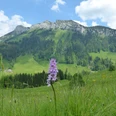
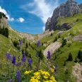
From the bus terminal Innereriz/Säge head valley inward and climb behind the holiday homes on a good stepped path through shaded forest. At the forest edge, beautiful views into the reddish glowing moor meadows of the Rotmoos nature reserve, to Grüenenberg Pass, the crossing to Habkern, and to the distinctive Sichle, the pass crossing to Lake Thun. The alpine path winds steeply upward in wide loops to Heimet Ober Breitwang. Magnificent view to Honegg and westward through Eriz. A good path crosses under the steep cliffs of Widderfeld the high hollow of Hungerschwand. Here yellow and purple gentian, light and dark monkshood bloom. After the ridge crossing on the alpine path to Wimmisalp. Schibengütsch and Schrattenflue now set the scenic highlights. Then through a rockfall zone, then through a forest scattered with mossy blocks to the huts of Gmeinenwängen.
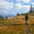
With alternating ups and downs it goes through sometimes swampy terrain to the hut of Grossenstein. From the slope shoulder at Luterschwändi, directly under the imposing cliffs of Hohgant, enjoy a wonderful view into the Lucerne pre-Alps. Then begins the long, sometimes pathless, often somewhat marshy descent over pastures to Baumgarten. A magnificent mountain maple stands by the hut. The valley hike along the young Emme to Kemmeriboden Bad lets you forget all efforts of the steep descent.

Good to know
Pavements
Best to visit
Directions
Innereriz - Wimmisalp - Luterschwändi - Baumgarten - Kemmeriboden Bad
Equipment
We recommend the following equipment: sturdy mountain boots, medium-sized backpack with hip belt, sun protection, rain gear, hiking poles, first aid kit, picnic, sufficient fluids, mobile phone.
Directions & Parking facilities
Outbound: by STI BUS from Thun to Eriz, Säge
Return: by bus from Kemmeriboden Bad
Additional information
Bernese hiking trails, Bern, Tel.: 031 340 01 01, E-mail: info@beww.ch, homepage: www.bernerwanderwege.ch
Literature
Hiking suggestion from the hiking book Emmental - Oberaargau, Bernese hiking trails book series.
License (master data)
Safety guidelines
This route runs entirely or partly on signposted paths of the mountain hiking trail category.
Map
Swisstopo hiking map 1:50,000 244T Escholzmatt
Nearby