- 6:00 h
- 14.22 km
- 1,600 m
- 800 m
- 1,170 m
- 2,640 m
- 1,470 m
- Start: Kandersteg
- Destination: Engstligenalp
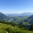
From Kandersteg station, walk along the railway embankment through the village. After a short time, the paved road passes under the railway line, crosses the Kander River and curves back to the left. A pleasant walk leads between the bank of the Kander and the edge of the forest valley inward to the scout home. On the west side of the Kander, the path then runs through gentle meadows, then turns right uphill through pastures and forest. After crossing an alpine road, you reach the little Üschene valley and the herdsmen's huts of Usser Üschene. The road passes the huts at Balme and Uf der Egge through the wide alpine valley between the Üschene ridge and the Lohner chain to Inner Üschene. In Inner Üschene/Leimeren, the path branches off uphill from the road and climbs steeply to the alpine basin of Ortele. In early summer, around mid-June, the slopes here delight hikers with alpine flowers. Through the cliff bands at the foot of the Ortelenhorn, after a strenuous ascent, you reach the ridge. Caution is advised when crossing the loose scree fields on the east flank of the prominent climbing towers of the Tschingellochtighorn. At the signpost on the southeast spur of the mentioned peak, you are already on the Engstligen ridge, which separates the Kandersteg region from the Adelboden region. Here you encounter chamois, usually marmots, and if you’re lucky, you’ll even see ibex climbing over the rocks. Below, the Tälliseeli shimmers, and in the background of the valley, the dazzling firn fields of the Tälligletsch glacier are visible. For the descent, follow the path westward and descend steeply on the south flank of the Tschingellochtighorn to the Ärtelengrat. Then you reach the alpine basin of the Engstligenalp via Chüematti. Throughout the entire descent, you have a magnificent view into the valley of the young Engstlige, onto Adelboden, the broad alpine plain, and the snow-covered ridge of the Wildstrubel. From Engstligenalp, the cable car provides a safe return to Kandersteg.

Good to know
Pavements
Best to visit
Directions
Kandersteg - Inner Üschene - Tschingellochtihorn - Engstligenalp
Equipment
We recommend the following equipment: sturdy mountain boots, medium-sized backpack with hip belt, sun protection, rainwear, hiking poles, pocket first aid kit, picnic, sufficient fluids, mobile phone.
Additional information
Bern Hiking Association, Bern, Tel.: 031 340 01 01, E-Mail: info@beww.ch, Homepage: www.bernerwanderwege.ch
License (master data)
Safety guidelines
This route runs entirely or partly on mountain hiking trails.
Map
Swisstopo hiking map 1:50,000 263T Wildstrubel
Nearby