


- 4:50 h
- 12.97 km
- 800 m
- 800 m
- 979 m
- 1,650 m
- 671 m
- Start: Aeschiried, Schulhaus
- Destination: Aeschiried, Schulhaus
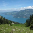
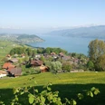
At the starting point, set off in the direction of Aeschiallmi – Brunni. After a short section of paved track, the trail climbs over alpine meadows and through woodland over the Greberegg to Brunni. Stop every now and again to take in the view back to the Aare valley or the Niesen, left over Lake Thun or right into the Suldtal and Kandertal valleys. In the woodland, you can catch a glimpse of Interlaken and Lake Brienz through the gaps in the trees. Straight ahead of you lies the Morgenberghorn. At the Sennhütte Brunni, take a right towards Louene and Suld. The path runs along the hillside to Huetmad where it turns right and descends sharply down to Louene. Continue down towards the valley and you’ll soon reach the Pochtenfall. Here you will find a rest stop, where you can relax for a while and marvel at the power of this majestic waterfall. The water tumbles from a height of over 80 metres down into the valley. Another descent takes you down to the Restaurant Pochtenfall in the Suld valley, which has hosted celebrities from all over the world. Now you join a peaceful, natural, mostly even stretch along the Suldbach. The trail, which is mostly wooded but crosses a brief stretch of meadow, is enjoyable and relaxing. At Staldeweid, the end of the hike is in sight. the remaining stretch to Aeschiried follows a paved track or gravel path beside a tarred road.

Good to know
Pavements
Best to visit
Directions
Equipment
Directions & Parking facilities
Getting back: Take the PostBus from Aeschiried, Schulhaus (school house) to Spiez and continue your journey by train
Additional information
License (master data)
Safety guidelines
Diese Route verläuft ganz oder teilweise auf signalisierten Wegen der Kategorie Bergwanderweg.
Map
Swisstopo Wanderkarte 253T Gantrisch 1:50’000
Nearby

