


- 2:00 h
- 6.28 km
- 135 m
- 440 m
- 1,770 m
- 2,078 m
- 308 m
- Start: Rinderberg
- Destination: Horneggli
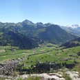
Already at the mountain station of the Rinderberg cable car, the impressive panorama captivates you. The panoramic view is completely overwhelming after overcoming some altitude on the broad, well-developed ridge path over the Gandlouenegrat: from Eiger, Mönch and Jungfrau through Wildstrubel and Diablerets to the Fribourg Alps extends a glowing ring of magnificent peaks. Ahead lies the striking elevation of Giferspitz. A slight descent leads to the alpine hut of Parwenge, where the path turns westward and now leads along the south flank of Horntube with the finest views of Saanenland. In the depths lies the Turbach valley, belonging to the municipality of Saanen, which has been able to preserve its character shaped by mountain agriculture until today. On the broad, gravelled farm road, you continue descending lightly to the alpine hamlet Hornberg/Uf de Chessle.
After a short ascent, the Hornflue is bypassed to the west, and soon the chair lift mountain station Horneggli is in sight. The view into the Saanenland, over to the Gastlosen and into the Simmental is wonderful.

Good to know
Pavements
Best to visit
Directions
Rinderberg - Gandlouenegrat - Parwenge - Hornberg - Horneggli
Equipment
We recommend the following equipment: sturdy mountain boots, medium-sized backpack with hip belt, sun protection, rainwear, hiking poles, pocket first aid kit, picnic, sufficient fluids, mobile phone.
Directions & Parking facilities
Outbound: by gondola from Zweisimmen to Rinderberg
Return: from Horneggli by chair lift to Schönried
Additional information
Berner Wanderwege, T 031 340 01 01, info@beww.ch, bernerwanderwege.ch
Literature
Hiking suggestion from the short hikes guidebook, guidebook series of Berner Wanderwege
License (master data)
Safety guidelines
This route runs entirely or partly on mountain hiking trails.
Map
Swisstopo hiking map 1:50,000 263T Wildstrubel
Nearby

