


- 2:00 h
- 5.16 km
- 530 m
- 50 m
- 1,486 m
- 1,926 m
- 440 m
- Start: Grütschalp
- Destination: Allmendhubel
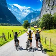
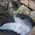
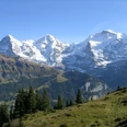
Already at the Grütschalp cable car mountain station, the imposing sight of the Eiger, Mönch, and Jungfrau peaks on the opposite side of the valley fascinates. A gentle ascent leads along a walking path to the edge of the forest, where a narrow mountain trail branches off. Here you gain altitude quickly in the shady mountain forest. The ascent is somewhat less steep once you reach the alpine pasture. The lush meadows of Alp Bletschen stretch out charmingly. Huge boulders in the middle of the grassland testify that a massive rockfall occurred here long ago. Another considerable ascent leads through a small forest, after which you reach the Bletschenalp trail junction. Practically flat paths, with occasional moderate climbs, now lead along a wonderfully scenic high route towards the valley. A continuously expanding panoramic view opens up to the rear Lauterbrunnen Valley and the rugged north faces enclosing it: west of the Jungfrau, Ebnefluh, Mittaghorn, Grosshorn, and Breithorn line up like glittering pearls. Several small mountain streams are crossed – the area at the foot of Dorenhubel is aptly named Siebenbrünnen. Further down, the streams flow together into the Staubbach, which cascades down a mighty cliff spraying into the valley floor. Over the higher pastures of Alp Winteregg, the path continues to Ägertenbach. A final ascent must be conquered here until the destination, the Allmendhubel viewing platform, is reached.

Good to know
Pavements
Best to visit
Directions
Grütschalp - Bletschenalp - Allmendhubel
Equipment
We recommend the following equipment: sturdy mountain boots, medium-sized backpack with hip belt, sun protection, rainwear, hiking poles, pocket first aid kit, picnic, sufficient fluids, mobile phone.
Directions & Parking facilities
Outbound: by cable car from Lauterbrunnen to Grütschalp.
Return: from Allmendhubel by funicular to Mürren.
Additional information
Bernese Hiking Trails, T 031 340 01 01, info@beww.ch, bernerwanderwege.ch
Literature
License (master data)
Safety guidelines
This route runs entirely or partly on marked trails of the mountain hiking path category.
Map
Nearby

")