


- 3:20 h
- 8.17 km
- 870 m
- 40 m
- 1,237 m
- 1,996 m
- 759 m
- Start: Lauenen
- Destination: Geltenhütte SAC
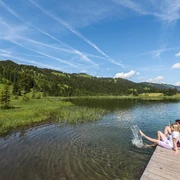
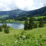
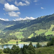
From the village center of Lauenen along the main road downstream to the Rohrbrügg group of houses. Directly after crossing the bridge, turn left and follow the Lauibach and pass through the Rohr nature reserve. After the wetland, you walk through a tranquil forest. Here, forest rangers have carved native animals from tree stumps along the path with chainsaws. They blend harmoniously into nature and distract from the short steep ascent. After overcoming this, the Lauenensee lies in a terrain hollow directly ahead, surrounded by moor meadows. Coots, mallards, and herons breed in this mountain lake, which is threatened by silting up and divided into two parts by a reed belt. In summer, there is often lively (and noisy) bathing activity here. At Büel (5 min to the bus station) the path enters the deeply cut upper valley section of the Geltenbach. Through a narrow gorge limited by the Mutt- and Follhore, one reaches, climbing steeply, the alpine pasture of the Undere Feisseberg. Now the view of the Geltenschuss opens. When looking at this series of cascades and whirlpools, one is doubly grateful for the past efforts of the people from Lauenen to keep this primeval landscape undeveloped. Deep views of the roaring water and the abundance of flowers along the way delight time and again.
On a good zigzag path, you now go up the steep slope through golden yellow arnica and colorful cushion plants in the scree. An involuntary shower cools the heated faces when passing behind a small waterfall before reaching the spot where the Geltenschuss plunges over the rock wall into the depths. About 15 minutes later, the hospitable Geltenhütte SAC is reached, where you are warmly welcomed (from Usseri Gelten–Chüetungel–Tungelschuss–Lauenensee 1h45, greatest caution on the flank of the Follhore; from Chüetungel–Usseri Tüüffi–Lauenen 2h20, caution on the walls of the Follhore and Holzersflue!). The valley end called Inneri Gelten is surrounded by a rocky, partially glaciated summit crown. The view over the Rottal, the Furggetäli, and downstream is overwhelming.

Good to know
Pavements
Best to visit
Directions
Equipment
We recommend the following equipment: sturdy mountain shoes, medium-sized backpack with hip belt, sun protection, rainwear, hiking poles, first aid kit, picnic, sufficient liquids, mobile phone.
Additional information
Literature
Hiking suggestion from the hiking book Simmental - Saanenland, hiking book series of the Bernese hiking trails
License (master data)
Safety guidelines
This route runs entirely or partly on marked paths of the mountain hiking trail category.
Map
Swisstopo hiking map 1:50,000 263T Wildstrubel
Nearby