Sledding path Wengernalp - Wengen (Fox Run)

4.46 km long
Difficulty: medium
Condition: easy
Great panorama
Sledding
  • 1:20 h
  • 4.46 km
  • 3 m
  • 600 m
  • 1,278 m
  • 1,875 m
  • 597 m
  • Start: Wengernalp (1873 m a.s.l.)
  • Destination: Wengen (1274 m a.s.l.)

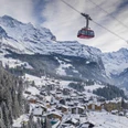
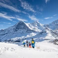
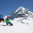
Sledding near the Lauberhorn downhill slope: From the Wengernalp train station, the sledding path passes under the small railway underpass and along the ski slope to the Bumpslift, Bannwald and towards Allmend (restaurant). 

From there, the path continues down to Wengen station. From Wengen, you can take the train back up to the starting point at Wengernalp: the Wengernalpbahn runs every 20 minutes. The sledding path is nicely laid out but still requires sledding experience. 

Berner Wanderwege
Berner Wanderwege

Good to know

Pavements

Gravel
Unknown
Path

Best to visit

suitable
Depends on weather

Directions

Accessibility of start location: Cogwheel railway

Equipment

Everyone is responsible for their own actions. Equipment: sled, good footwear, weather-appropriate clothing, gloves, hat and helmet, provisions including a warm drink, emergency number.

Directions & Parking facilities

By car via Interlaken to Lauterbrunnen.
Parking available in Lauterbrunnen.
Outbound and return journey: By train via Interlaken to Lauterbrunnen. Continue to Wengen and towards Kleine Scheidegg up to the Wengernalp stop.

Additional information

Wengen Tourism
Dorfstrasse
CH-3823 Wengen
Tel. +41 33 856 85 85
info@wengen.ch
http://www.wengen.ch

License (master data)

Author´s Tip / Recommendation of the author

Sled rental on site: yes

Safety guidelines

Everyone is responsible for their own actions.

Map

Swisstopo national map 1229 Grindelwald 1:25'000, order at: https://www.wanderplaner.ch/sommer/web-shop/

Nearby

Contact

Sledding path Wengernalp - Wengen (Fox Run)
Lauterbrunnen