


- 2:50 h
- 8.07 km
- 400 m
- 740 m
- 705 m
- 1,392 m
- 687 m
- Start: Heiligenschwendi
- Destination: Sigriswil
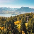
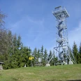
On the opposite side of the REHA Zentrum, we follow the signs towards Blueme and ascend gently through the forest. From the Wolfgruebe junction (P.1245) we continue gaining altitude on the gently defined ridge and soon reach the summit of Blueme with its lookout tower.
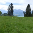
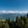
Up to the P.1379 junction, we return on the same path. Here we keep slightly left and begin the descent on a wonderful forest path. At Tschingelallmi, we leave the forest and a magnificent panorama opens before us. Partly on a wide ridge over Margelsattel and the summit of Margel, we descend to Tschingel. From Tschingel, there are two options to reach Sigriswil.
Those who want to cross the large panorama bridge follow the signs via Aeschlen to Sigriswil. With a length of 340 meters and a height of 180 meters, the panorama bridge is an amazing structure. Should anyone not dare to cross the bridge, there is also the option to reach Sigriswil via the Gummischlucht from Aeschlen.
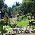
If you choose in Tschingel the approximately 20 minutes shorter and somewhat less spectacular path to Sigriswil, you will reach the hidden Grabenmühle along the way. Here, besides a stopover, you can try gold panning or trout fishing. A great final experience for families.

Good to know
Pavements
Best to visit
Directions
Equipment
Directions & Parking facilities
Arrival: by bus from Thun station to Heiligenschwendi, stop REHA Zentrum
Return: from Sigriswil village stop to Thun station
Additional information
Literature
Hiking book Bernese Oberland by the Bernese Hiking Trails
License (master data)
Safety guidelines
Map
Swisstopo hiking map 253T Gantrisch & 254T Interlaken 1:50,000
Nearby


")
")