


- 4:20 h
- 12.96 km
- 720 m
- 720 m
- 560 m
- 1,103 m
- 543 m
- Start: Thun
- Destination: Thun
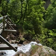
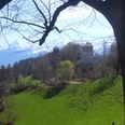
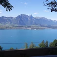
From the Seematte bus stop, ascend to the village of Hünibach. At the top of the village, cross the stream and turn back downstream at the old schoolhouse into the cool, wooded Cholera Gorge. The excellently developed hiking trail winds over small bridges and steps up through the gorge. Towering vertical conglomerate walls rise on both sides of the path. In the middle of the gorge, there is a beautiful resting place by a massive erratic boulder. The path then zigzags up to Goldiwilstrasse, which is to be followed 100 m to the right. Now, keeping the direction, turn onto the uphill farm track. After leaving the forest, passing a farmstead, you quickly gain altitude. The view widens backwards to Niesen and the Bernese Alps. Ahead appears the beautifully situated cluster of houses around the church of Goldiwil (towards Heiligenschwendi-Dörfli–Stierenegge–Hilterfingen 1h30). Goldiwil was incorporated into Thun in 1913 to provide growing space for the city. The gentle crossing of the upper Cholera valley offers magnificent views of the lower Lake Thun basin, Belpberg, Gurnigel, and the Stockhorn range.
In Äbnit (towards Heiligenschwendi/Schoolhouse–Stierenegge–Hilterfingen 1h15) you initially head downhill, but above the forest turn to the road to Schwendi. Schwendi lies in a splendid southern location high above the lake. It is part of the extensive municipality of Heiligenschwendi. There is no village by this name. Heiligenschwendi became known because of the nearby first public sanatorium for tuberculosis patients, opened in 1895 by the two main promoters Drs. Glaser and Schwab. Today the Bernese Höhenklinik Heiligenschwendi mainly treats asthma and orthopedic conditions as well as heart diseases.
Over wide alpine ridges down to Ober Allmit (to Allmit–Oberhofen 50 min, to Allmit–Hilterfingen 1h) and with slight ups and downs over Halte to Stierenegge (to Hilterfingen 1h), a top viewpoint. Over lush meadows and through forest, the well-maintained trail then steeply descends to Hünibach.

Good to know
Pavements
Best to visit
Directions
Equipment
Directions & Parking facilities
Additional information
Literature
License (master data)
Safety guidelines
Map
Nearby


