- 4:40 h
- 12.28 km
- 1,002 m
- 523 m
- 784 m
- 1,664 m
- 880 m
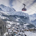
- Start: Lauterbrunnen
- Destination: Wengen
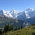
For only a short time, you follow the main road inland from Lauterbrunnen station. Then the hiking trail turns left into the valley floor and becomes the riverside path along the Weisse Lütschine. The spectacle of the Staubbach Falls, which at about 300 m is one of the most impressive waterfalls in Europe, is wonderful. Particularly pleasing is the fact that the municipality of Lauterbrunnen was able to purchase the Staubbachhubel in 1996 and thus ensure free access to the falls. In the background of the valley, the silver ribbons of the Schmadribach stretch over the rocks. Above, the glacier walls at the Gross- and the Breithorn gleam. After a short detour to the foot of the Mürrenflue Bir Buechen, the path crosses the valley floor to the Hotel Trümmelbach. About 300 m further inland, a field path leads to the foot of the steep slope. The further path is only suitable for experienced mountain hikers!
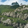
Next to the lowest waterfall, the climb begins. On blasted steps, the path, partially secured with wire cables, leads quickly higher in a zigzag. Soon, the difficult sections become less frequent, and the path descends slightly to the footbridge over the Trümmelbach (caution!). Almost eerie is the deep view into the narrow, deeply incised gorge of the Trümmelbach. At Preech, the detour to the lower hut is worthwhile: Three waterfalls plunge into the rocky hollow of the valley, and above, the massive ice formations from the Eiger to the Schwarzmönch tower.
Still climbing steeply, you reach the gentler meadows of Stalden on a good forest path (to Mettla–Wengernalp 50 min, –Kleine Scheidegg 1h35; to In Gassen–Wengen 1h15). The deep view from the nearby Staldeflue is unique. Where else can you look vertically down over an 800 m high rock wall unhindered into the valley floor? Pleasant is the concluding traverse on a good path over Schiltwald to Wengen.

Good to know
Pavements
Best to visit
Directions
Lauterbrunnen - Trümmelbach - Preech - Staldeflue - Wengen
Equipment
We recommend the following equipment: sturdy mountain boots, medium-sized backpack with hip belt, sun protection, rain gear, hiking poles, first aid kit, picnic, sufficient fluids, mobile phone.
Directions & Parking facilities
Arrival: By train via Interlaken Ost to Lauterbrunnen.
Return: By train from Wengen to Lauterbrunnen and onward to Interlaken Ost
Additional information
Berner Wanderwege Association, Bern, Tel.: 031 340 01 01, E-Mail: info@beww.ch, Homepage: www.bernerwanderwege.ch
Literature
Hiking suggestion from the hiking book Jungfrau Region Brienzersee - Oberhasli, hiking book series of the Berner Wanderwege
License (master data)
Author´s Tip / Recommendation of the author
The visit to the world-famous Trümmelbach Falls requires a fee and is not part of this hike!
Safety guidelines
This route runs wholly or partly on signposted trails of the mountain hiking trail category.
Map
Swisstopo hiking map 1:50,000 264T Jungfrau
Nearby