- 2:15 h
- 7.58 km
- 57 m
- 680 m
- 1,170 m
- 1,789 m
- 619 m
- Start: Allmenalp
- Destination: Kandersteg
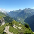
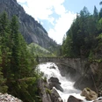
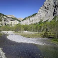
High above the valley floor, above almost vertical rock walls, lies the Allmenalp. Only those who are absolutely sure-footed can reach it on foot: a via ferrata rated as challenging leads over rock ledges, hanging ropes, and Nepalese bridges to the heights. The starting point of the hiking trail can be reached more comfortably by cable car. The valley station is located 15 minutes on foot southwest of Kandersteg station on the hiking trail towards Eggeschwand. From the Allmenalp mountain station, you enjoy a wonderful panoramic view down to Kandersteg and to Lake Oeschinen. On a wide gravel path, it goes with a moderate ascent first in a wide arc to the opposite slope, then on a scenic high trail with slight ups and downs through mountain forest and over alpine pastures. At height, the sharply jagged rock towers of the Lohner group appear, ahead lie Fisistock and Altels. At Ryharts, the gravel path begins to descend and leads with a pleasant slope into the Üschenetal. Soon the view opens into the wide, picturesque high valley. At the Alpstafel Schwymbödi, the route leaves the gravel path and crosses the alpine pasture along a dry stone wall down to Usser Üschene (point 1548). Alternatively, the hike can be continued on the gravel path to Usser Üschene (point 1595). During the alpine summer, a simple mountain restaurant is open there; on an asphalt alpine road or cross-country over the pasture, you return to the original route. It then goes somewhat steeper down to Eggeschwand on a sometimes narrow path, from there along the Kander to the scout center, further to the valley station of the Allmenalp cable car, and finally to Kandersteg station.

Good to know
Pavements
Best to visit
Directions
Allmenalp - Ryharts - Usser Uschene - Kandersteg
Equipment
We recommend the following equipment: light trekking shoes, light backpack, sun protection, rain jacket, pocket first aid kit, light picnic, sufficient fluids, mobile phone.
Directions & Parking facilities
Getting there: by train to Kandersteg. On foot to the Allmenalp cable car.
Return: by train from Kandersteg
Additional information
Bernese Hiking Trails, T 031 340 01 01, info@beww.ch, bernerwanderwege.ch
Literature
Hiking suggestion from the hiking book 'Short Hikes', hiking book series of the Bernese Hiking Trails
License (master data)
Safety guidelines
This route runs exclusively on hiking trails.
Map
Swisstopo hiking map 1:50,000 263T Wildstrubel
Nearby