


- 2:50 h
- 10.67 km
- 186 m
- 123 m
- 575 m
- 761 m
- 186 m
- Start: Allmendingen near Thun, turning point
- Destination: Amsoldingen, Kreuz
From the bus stop, the hiking trail leads along the quietly flowing Glütschbach into the romantically wild little valley and further to the impressive stalactite caves. In front of the caves, a covered barbecue area invites you to linger, and children are drawn to play in the shallow Glütschbach. Before the Kander was diverted into Lake Thun over 300 years ago with the Kander breakthrough, it flowed through this valley and emptied west of Thun into the Aare. This repeatedly led to flooding. After the diversion, the former Kander streambed dried up and the groundwater level dropped significantly. The surrounding communities could no longer operate their mills and could no longer irrigate their fields. Thus, the Glütschbach was channelled and diverted into the old Kander bed, which improved the water situation again.
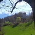
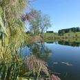
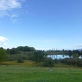
Past the stalactite caves, the trail goes uphill, out of the Glütschbach valley, where a magnificent view of the Stockhorn opens up. The ascent is varied; soon the highest point with the Hohlinden restaurant is reached. The destination, Amsoldingen, already seems within reach, but the scenic hike continues along the ridge for a while longer. After a short descent, Amsoldingen with its lake and church is reached. The pilgrimage route to Santiago de Compostela passes by the church, making it well known far and wide.

Good to know
Pavements
Best to visit
Directions
Allmendingen – Glütschbach valley – Hohlinden – Höfen b. Thun – Amsoldingen
Equipment
We recommend the following equipment: light trekking shoes, light backpack, sunscreen, rain jacket, first aid kit, light picnic, enough liquids, mobile phone.
Directions & Parking facilities
Arrival: from Thun, train station with the bus to Allmendingen near Thun, turning point
Return journey by bus from Amsoldingen, Kreuz to Thun, train station
Additional information
Berner Wanderwege, 031 340 01 01, info@beww.ch, bernerwanderwege.ch
License (master data)
Safety guidelines
This route runs exclusively on signposted paths in the hiking path category.
Map
swisstopo hiking map 1:50 000, 253 T Gantrisch
Nearby
