


- 1:45 h
- 4.19 km
- 46 m
- 650 m
- 1,615 m
- 2,138 m
- 523 m
- Start: Stockhorn
- Destination: Chrindi
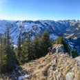
The proposal described here starts at the mountain station of the Stockhorn cable car. Do not miss the short ascent to the summit (magnificent panoramic view) or stroll through the tunnel to the Sockhorn windows, from where a dizzying view down to Lake Thun is possible.
The descent crossing the Stockenfeld to Oberstocken is very steep, but the path is excellently constructed. Wonderful are the views along the way over the deep blue eye of Oberstocken Lake to the Simmental and Saanenland mountains. At the Oberstocken Alp, the friendly hospitality tempts you to a shorter or longer stop. The same family has spent about three and a half months of alpine pasture here for eight generations. Now continue first towards Oberstocken Lake, then swing through a karstified forest hollow rich in rare alpine flowers to Hinterstocken and climb via the rock path carved into the Mieschflue up to the Chrindi mid-station of the Stockhorn cable car. The path is consistently well secured.

Good to know
Pavements
Best to visit
Directions
Equipment
Directions & Parking facilities
Outbound: By train via Spiez to Erlenbach im Simmental. Then on foot to the Stockhorn cable car (15 min). Take the cable car to the mountain station.
Return: From the Chrindi mid-station to Erlenbach. On foot to Erlenbach im Simmental train station.
Additional information
License (master data)
Safety guidelines
Map
Nearby


")
")
")