


- 3:30 h
- 12.55 km
- 160 m
- 1,000 m
- 1,328 m
- 2,166 m
- 838 m
- Start: First (Grindelwald)
- Destination: Rosenlaui
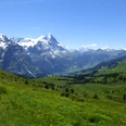
From the upper station of the First cable car, the route's path can already be seen to the east. The path first descends to Distelboden. Then, in a wide arc, the hollow is crossed over the alpine huts of Schreckfeld. The more the path turns southwards, the more impressive the view of the Eiger, Schreckhorn, and Wetterhorn becomes. Blueberries and dwarf junipers line the path, which is crossed repeatedly by streams. At the Grindel/Oberläger alpine huts, the upper path can be continued to Gratschärem. Now the Gutz Glacier on the Wetterhorn flank is clearly visible. From Gratschärem there is a clear view to the east. The Reichenbach Valley with its wide alpine pastures and dark forests spreads out; behind it stand the rugged, jagged walls of the Engelhörner. The route continues along the saddle ridge of the Grosse Scheidegg, the watershed that separates the catchment area of the Schwarze Lütschine from that of the Rychenbach and thus the Hasli Valley. The mighty Wetterhorn wall, which here towers almost vertically, is impressive. At the Grosse Scheidegg, the descent begins through alpine meadows to Alpiglen and Schwarzwaldalp. From there the path leads through moss-covered forests and along the Rychenbach to the historic Hotel Rosenlaui.
At the mountain station of the First cable car, a walk on the "Cliff Walk" is worthwhile. A suspension bridge and a footbridge have been built on the steeply falling rock face. From there, the mountain scenery can be safely enjoyed. To be admired are the Eiger, alpine pastures, and forests.
In 1996, 220,000 cubic meters of ice thundered from the Gutz Glacier on the flank of the Wetterhorn downwards. The ice masses, up to 100 meters wide and 20 meters high, lay on the Grosse Scheidegg. Since then, the glacier has been constantly monitored.
The Grosse Scheidegg is the pass connecting Grindelwald in the Schwarze Lütschine valley with Meiringen in the Hasli valley. The pass height is just under 2000 meters above sea level, below the Wetterhorn. Long before tourists discovered the Grosse Scheidegg in the 19th century, the crossing served as a pass connection between the Grindelwald and Hasli valleys.
Rosenlaui lies in the middle of the Reichenbach Valley and recalls with its historic hotel the early days of tourism in Switzerland. The Hotel Rosenlaui has been welcoming guests since 1771, and every corner of the hotel is shaped by its great history. The older part of the building was built in 1862 after a fire and houses the dining room and rooms. The salons, restaurant, and other rooms are located in the Belle Époque hotel from 1905.

Good to know
Pavements
Best to visit
Directions
First – Grosse Scheidegg – Schwarzwaldalp – Rosenlaui
Equipment
We recommend the following equipment:
Sturdy mountain boots, medium-sized backpack with hip belt, sun protection, rain gear, trekking poles, first aid kit, picnic, sufficient fluids, mobile phone.
A luggage transport from stage accommodation to stage accommodation can also be booked on short notice via Eurotrek. Information and conditions at Eurotrek.ch.
Directions & Parking facilities
Arrival: by train via Interlaken Ost to Grindelwald. On foot or by bus to the valley station of the First cable car. Take the gondola up to the mountain station.
Return: from Rosenlaui by bus to Meiringen or Grindelwald station.
Additional information
The ViaBerna is a multi-day hike consisting of 20 stages from Bellelay across the canton of Bern to the Susten Pass. Along the way, the hiker experiences the diversity of the canton of Bern in the Jura, the Swiss Plateau, and the Bernese Alps. The entire route is marked with route number 38.
Information about the multi-day hike ViaBerna can be found at viaberna.ch
License (master data)
Author´s Tip / Recommendation of the author
Shopping options: No shops along the way. On arrival and departure in Grindelwald or Meiringen.
Accommodation tip Grindelwald/First: Berggasthaus First, P.O. Box 138, 3818 Grindelwald, Tel. 033 828 77 88, berggasthausfirst@jungfrau.ch, www.berggasthausfirst.ch
Other accommodations in Grindelwald.
Accommodation tip Rosenlaui: Hotel Rosenlaui, 3860 Rosenlaui, Tel. 033 971 29 12, info@rosenlaui.ch, www.rosenlaui.ch
Alternative: Hotel Schwarzwaldalp, 3860 Meiringen, Tel. 033 971 35 15, info@schwarzwaldalp.ch,www.schwarzwaldalp.ch or
Gasthaus Zwirgi, 3860 Schattenhalb, Tel. 033 971 14 22, gasthaus@zwirgi.ch,zwirgi.ch
Safety guidelines
This route runs entirely or partially on marked trails of the mountain hiking trail category.
Map
swisstopo hiking map 254T Interlaken 1:50,000
Nearby

