


- 7:00 h
- 18.49 km
- 1,530 m
- 750 m
- 1,057 m
- 2,256 m
- 1,199 m
- Start: Hasliberg, Reuti
- Destination: Engstlenalp
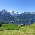
The path from Hasliberg-Reuti to the Planplatten leads over the Underen and Oberen Stafel as well as the Underi and Oberi Syten, an impressive ridge that is also accessible by gondola and has a panoramic restaurant. During the ascent, you will come across the Zwergenweg (Dwarfs' Path) in the Gummalp forest. At the mountain station it is worth visiting the terrace of the "Alpen Tower." From here, you can spot Lake Brienz, the Aare valley, and the Wetterhorn. The Balmeregghorn is reached by a mountain trail alternating downhill and uphill. On the right, there is a view into the Gental valley and to the Gadmerflue. The Balmeregghorn is the highest point of the hike. The following ridge path forms the canton border to Obwalden up to Ärzegg. On the left, you can see Lake Melchsee and later Lake Tannensee. On the ridge, later over alpine pastures, you descend towards Lake Tannensee. After the alpine settlement Tannalp, there is a section at Geisstritt with exposed parts. A few years ago, this passage was elaborately developed and equipped with a cable. The passage is now passable for everyone. Then the trail changes from Obwalden back to the canton of Bern. Over an alpine pasture and streams, you reach the Engstlenalp. The idyllic Engstlensee must not be missed. The cool and clear water is relaxing and rewards the effort.
The mountain world is richly blessed with dwarfs. The best-known dwarf in Hasliberg is called Muggestutz, and so the adventure path was named, which was one of the first established in the Bernese Oberland between Mäglisalp and Bidmi. Every summer, the Zwergenweg is a popular excursion destination for families.
Field names like Erzgrueben and Ärzegg indicate that iron ore was mined and mining was conducted on the ridge centuries ago. The material was transported laboriously from the mountain to a blast furnace near Innertkirchen.
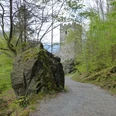
The Engstlenalp, located high above Innertkirchen in a basin at 1850 meters, is considered one of the most beautiful alpine pastures in Switzerland and is a remote, quiet snow paradise in winter.
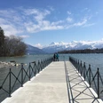
The Hotel Engstlenalp has been welcoming guests since 1892 and lies directly near Lake Engstlenalp, whose surface reflects the peaks surrounding the Engstlenalp. The lake is located at the foot of the glaciated Titlis and is surrounded by diverse flora and ancient larches, which stand on the northern shore amidst the hilly moraine landscape. Because of its location, the area has been placed under nature conservation.

Good to know
Pavements
Best to visit
Directions
Hasliberg – Planplatten – Balmeregghorn – Tannalp – Engstlenalp
Equipment
We recommend the following equipment:
Sturdy hiking boots, medium-sized backpack with hip belt, sun protection, rainwear, hiking poles, first aid kit, picnic, sufficient fluids, mobile phone.
Luggage transport from one stage accommodation to the next can also be booked on short notice via Eurotrek. Information and conditions at Eurotrek.ch
Directions & Parking facilities
Paid parking spaces near the valley station of the Meiringen-Hasliberg/Reuti cable car. Then take the cable car to Reuti.
For the return by train from Innertkirchen, use the Meiringen Alpbach stop.
Arrival: by train via Interlaken Ost to Meringen. Then by cable car to Hasliberg, Reuti.
or by train from Lucerne over the Brünig Pass. Then by bus to Hasliberg, Reuti.
Return: from Sat. July 5 the Engstlenalp bus operates. Please check the timetable and conditions on the following website:
Alternatively, a taxi can be ordered:
Additional information
The ViaBerna is a multi-day hike that leads in 20 stages from Bellelay across the canton of Bern to the Susten Pass. Along the way, hikers experience the diversity of the canton of Bern in the Jura, the Central Plateau and the Bernese Alps. The entire route is marked with route number 38.
Information about the ViaBerna multi-day hike can be found at viaberna.ch
License (master data)
Author´s Tip / Recommendation of the author
Accommodation tip Hasliberg: Hotel Reuti, Engi 485, 6086 Hasliberg Reuti, Tel. 033 972 53 00, info@hotelreuti.ch, www.hotelreuti.ch
Alternative: Gasthof zur Post, Dorf 316, 6085 Hasliberg, Tel. 033 971 35 34, www.gasthofzurpost.ch
Shopping facilities: village shop Hasliberg/Reuti
Accommodation tip Engstlenalp: Hotel Engstlenalp, Engstlenalp, 3862 Innertkirchen, Tel. 033 975 11 66, info@engstlenalp.ch, www.engstlenalp.ch
Alternative:
Berggasthaus Tannalp, Tannalp, 6068 Melchsee-Frutt, Tel. 041 669 11 47, info@tannalp.ch,www.tannalp.ch
Rossbodenhütte, Engstlenalp, 3862 Innertkirchen, Tel. 033 550 50 50, info@meiringen-hasliberg.ch
Safety guidelines
This route runs entirely or partially on marked paths in the mountain hiking trail category.
The ascent from Hasliberg/Reuti to Planplatten is strenuous. Alternatively, the gondola can be used to Bidmi, Mägisalp or Planplatten.
Map
swisstopo hiking map 255T Sustenpass 1:50,000
Nearby