


- 7:00 h
- 17.98 km
- 1,408 m
- 631 m
- 1,058 m
- 2,256 m
- 1,198 m
- Start: Hasliberg-Reuti
- Destination: Engstlenalp
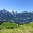
Sleep like a marmot in a nostalgic room at one of the most beautiful mountain lakes in the Bernese Oberland. That sounds tempting as a day's destination after a long and eventful hiking day on the Horizon Path from Planplatten to Engstlenalp! In addition, a paradisiacal landscape, quiet places of peace and retreat, a historic hotel, the ringing of cowbells, the cozy atmosphere of a lounge, «where once scholars, farmers and craftsmen sat together at the table». Who doesn't dream of something like that! Such dreams come true at Engstlenalp. And the theme of a power spot is also present. Because somewhat away from the lakeshore there is a moraine ridge, on which a large stone next to an old Swiss pine rises into the sky. The place is much visited, as it is listed in the relevant literature. Such a place is just right to recharge after a strenuous hiking day. And of course, a refreshing swim in the cool lake is very welcome.

Good to know
Pavements
Best to visit
Directions
Hasliberg-Reuti (1064 m) – Eggli – Oberegg (1317 m) – Undere Stafel (1626 m) – Obere Stafel (1830 m) – Planplatten (2229 m) – Balmergghorn (2254 m) – Erzegg – Tannensee (1982 m) – Tannalp (1974 m) – Engstlenalp (1835 m).
Equipment
For day trip, normal hiking equipment; for multi-day trips, including spare clothes and provisions. Hiking poles are recommended.
Directions & Parking facilities
Arrival: By train to Meiringen, then gondola to Reuti.
Return: From Engstlenalp post bus connection to Innertkirchen, there train connection towards Meiringen.
Additional information
Haslital Tourism, Tourist Center Meiringen, 3860 Meiringen, Tel. +41 (0) 33 972 50 50, www.haslital.swiss
Places to eat, e.g.:
Panorama Restaurant Alpen Tower Planplatten, Tel. +41 (0) 33 972 53 26
Mountain inn Tannalp, Tel. +41 (0) 41 669 12 41, www.tannalp.ch
Accommodation, e.g.:
Hotel Engstlenalp, Tel. +41 (0) 33 975 11 61, www.engstlenalp.ch
Literature
Jochen Ihle / Toni Kaiser: The 101 most beautiful hikes of Switzerland. ISBN 978-3-03865-041-6, Rothus Medien, Solothurn, www.wandershop-schweiz.ch
Wandermagazin SWITZERLAND, special issue 1/2022: ViaBerna. Rothus Medien, Solothurn, www.wandermagazin-schweiz.ch
License (master data)
Author´s Tip / Recommendation of the author
Planplatten can also be reached by cable cars from Reuti via Mägisalp, which saves about 1200 meters of ascent or 3½ to 4 hours of climbing.
Safety guidelines
The Horizon Path Planplatten – Tannalp requires sure-footedness. Marked mountain hiking trail. Difficulty: T3.
Map
Map 1:50,000, 255T Susten Pass.
Nearby

