


- 4:30 h
- 11.97 km
- 600 m
- 1,250 m
- 1,198 m
- 2,117 m
- 919 m
- Start: Engstlenalp
- Destination: Gadmen, Post bus stop
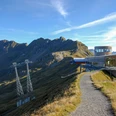
From Hotel Engstlenalp, the route first gently ascends on a forest road to Engstlensee. Magnificent is the view over the blue-green shimmering water to the Jochpass and the Titlis area. Downhill, several mountain ridges are then bypassed. From Scharmad, you enjoy the magnificent view through the wooded, quiet Gental to the peaks of the Upperland ice giants. The path runs almost horizontally above the tree line through the descending mountain slope to Bäregg. Gently ascending, it now goes through the open terrain below the Tällistock. The Sätteli, the transition to the Gadmertal, approaches. Noticeable to the right are the Sättelisteckleni, a rugged rock formation that, like the Gadmerfluh, resembles the Dolomites in South Tyrol. From the Sätteli, you enjoy a magnificent view: firn and ice, forest and meadows, from the climbing mountains of the Engelhörner to the Finsteraarhorn and over the glittering glaciers of the Trift, the Sustenhorn and the Titlis, everything lies open. The descent between rock bands is steep. The now following second part of the high-altitude hike passes the Tällihütte and the towering rock towers of the Gadmerflue along Alpligen to Raflue. Here begins the rapid descent to the mountain village of Gadmen, 400 meters below.
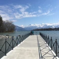
The Engstlensee is a natural lake at the foot of the glacier-covered Titlis, surrounded by diverse flora and ancient larches standing amid the hilly moraine landscape. The area is under nature protection.
The Gental is a sparsely populated side valley of the Gadmertal. At the upper end is the Engstlenalp with Engstlensee and over the Jochpass there is a footpath connection to the Engelberg valley.
The Tälli via ferrata leads from the Berghaus Tälli through the Gadmerfluh. It was the first via ferrata in Switzerland and at 600 meters in length still counts among the longest and most spectacular in Switzerland.
Despite good access via the pass road, some income from tourism and the Oberhasli power plants operating here, job prospects in the mountain village of Gadmen are modest. In past centuries, many Gadmer emigrated. Today, the village, which is threatened by avalanches in snowy winters, is challenged by migration to the lowlands.

Good to know
Pavements
Best to visit
Directions
Engstlenalp – Sätteli – Tällihütte – Raflue – Gadmen
Equipment
We recommend the following equipment:
Sturdy mountain boots, medium-sized backpack with hip belt, sun protection, rainwear, hiking poles, pocket pharmacy, picnic, sufficient fluids, mobile phone and hiking poles.
Luggage transport from one overnight stop to the next can also be booked at short notice via Eurotrek. Information and conditions at Eurotrek.ch
Directions & Parking facilities
Arrival: by train via Meiringen to Innertkirchen. From there the Engstlenalp bus runs. Please check the timetable and conditions on the following website: https://engstlenalp-bus.ch/
Return: by bus from Gadmen Post to Innertkirchen Grimseltor
Alternatively, a taxi can be ordered:
https://www.alpenbustaxi.ch/
https://www.grimseltaxi.ch/
Additional information
The ViaBerna is a multi-day hike consisting of 20 stages from Bellelay across the Canton of Bern to the Sustenpass. Along the way, the hiker experiences the variety of the Canton of Bern in the Jura, the Central Plateau, and the Bernese Alps. The entire route is signposted with route number 38.
Information on the multi-day hike ViaBerna can be found at viaberna.ch
License (master data)
Author´s Tip / Recommendation of the author
Shopping options: No shops along the route.
Accommodation tip Engstlenalp: Hotel Engstlenalp, Engstlenalp, 3862 Innertkirchen, Tel. 033 975 11 66, info@engstlenalp.ch, www.engstlenalp.ch
Alternatives:
Berggasthaus Tannalp, Tannalp, 6068 Melchsee-Frutt, Tel. 041 669 11 47, info@tannalp.ch, www.tannalp.ch
Rossbodenhütte, Engstlenalp, 3862 Innertkirchen, Tel. 033 550 50 50, info@meiringen-hasliberg.ch
Accommodation tip Gadmen: Hotel Restaurant Gadmer Lodge, Gadmen 283a, 3863 Gadmen, Tel. 033 975 00 30, info@gadmerlodge.ch, www.gadmerlodge.ch
Safety guidelines
This route runs wholly or partly on marked paths of the mountain hiking trail category. In the ''Sätteli'' area, the trail leads over a steep descending section partly covered with loose stones. Surefootedness and good footwear are absolutely necessary. Hiking poles can be helpful!
Map
swisstopo hiking map 255T Sustenpass 1:50,000
Nearby
