


- 4:00 h
- 10.87 km
- 426 m
- 410 m
- 1,938 m
- 2,202 m
- 264 m
- Start: Gstaad/Wasserngrat
- Destination: Lenk/Betelberg
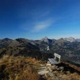
With the Wasserngratbahn, we reach the mountain station at Dürrischilt on the Wasserngrat. Through dense alder bushes, over grassy slopes and rocky bands, the ascent leads to the distinctive ridge. The path is narrow but secured with ropes at exposed sections. It leads around rock towers, along steep cliff faces, and finally directly over the ridge to the resting bench on the Wandeliflue, the highest point of the hike. Magnificent panoramic views over the Saanenland to the Gastlosen and deep views into the Lauenen or Turnelstal. To the south, the peaks and glaciers of the Wildhorn and Diablerets groups line up. After descending to the shelter at Brüeschegrat, the difficult sections are overcome. From Turnelssattel – named Baumersberg on the national map – (to Bachberg–Scheidbach–Gstaad 2h20; to Lauenen 1h30) a unique high-altitude hike like no other. First, one crosses the Wildheu and chamois pastures on Lauenehore. At the Türli, various descent options are offered again (to Turbach–Gstaad 3h, to Lauenen 1h30). Below the summit of the Tube, the path leads over to the Trütlisbergpass and further southwards. The path soon passes through a unique crater landscape. Dozens of partially impressively large sinkholes have formed here over time in the Gryden – an extensive gypsum region. Before the highest point at the Stübleni, the path goes through its northern flank to the Gryde signpost and then along a flat path to the Leiterli mountain station on Betelberg. Along the way, one enjoys magnificent views of the Wildstrubel and the peaks on the left and right of the Rawil Pass.

Good to know
Pavements
Best to visit
Directions
Equipment
Directions & Parking facilities
Outbound journey: By train to Zweisimmen and further to Gstaad, then by bus to Gstaad, Wasserngratbahn and further by chairlift to Wasserngrat
Return journey: By gondola from Betelberg, from Lenk by train
Additional information
Literature
Hiking suggestion from the hiking book Panoramawanderungen
License (master data)
Safety guidelines
Map
swisstopo hiking map 1:50,000 263T Wildstrubel
Nearby
