- 3:40 h
- 11.99 km
- 1,636 m
- 595 m
- 2,231 m
- 1,636 m
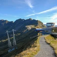
- Start: Planplatten
- Destination: Meiringen
(Route described in reverse direction) From Meiringen station, walk 150 m eastwards, then turn uphill and reach the culturally and historically interesting church. Then continue eastwards past the Hasli landscape museum and to the large protective wall built against Alpbach floods. After the bridge, the path turns uphill along the slope and winds in many switchbacks through the forest up to Schränli. Beautiful larch stands provide soothing shade. Among them are beech, elm, lime, and occasionally oak trees. After leaving the forest, enjoy a magnificent deep view of the valley floor. Beyond the Alpbach, a small lake is visible between masonry banks, the collection basin of the municipal power plant. The upper power station at the lake was commissioned in 1950. However, the beginnings of the plant date back to 1889. Shortly before, the Aare Gorge was opened. Also, the first locomotive was already puffing across the Brünig. This small power plant was one of the first in Switzerland and supplied electricity for about 400 carbon filament lamps with a light intensity of 16 candles. Between Alpbach and the suspension cables of the Meiringen-Hasliberg railway, the path goes through the forest to Brünigstein (25 minutes to Goldern), then fairly steeply uphill over meadows to Hasliberg Reuti. Extensive spring catchments are located on its ground, from which Meiringen sources part of its drinking water. Also, for the varied further ascent via Eggli–Oberegg–Point 1457 (to the intermediate station Bidmi 5 min; to Gummen–Planplatten 2h15, mountain hiking trail)–Mägisalp, the aerial cableway roughly guides the way. At the mountain station at Mägisalp, keep straight ahead and after a short steep ascent reach the spacious plateau of Hinder Tschuggi. Above it—at an altitude of 1980 m—the ascent route merges into the high-level path leading from Käserstatt to Planplatten. However, it is necessary to overcome a further altitude difference of just over 200 m until you can enjoy the magnificent view from the summit. This is overwhelming and soon makes you forget the exertion of the ascent.

Good to know
Pavements
Best to visit
Directions
Planplatten - Mägisalp - Reuti - Schränli - Meiringen
Equipment
We recommend the following equipment: sturdy mountain boots, medium-sized backpack with hip belt, sun protection, rainwear, hiking poles, first aid kit, picnic, sufficient fluids, mobile phone.
Additional information
Association Berner Wanderwege, Bern, Tel.: 031 340 01 01, E-mail: info@beww.ch, homepage: www.bernerwanderwege.ch
Literature
Hiking suggestion from the Jungfrau Region Brienzersee - Oberhasli hiking book of the Bernese Hiking Trails.
License (master data)
Author´s Tip / Recommendation of the author
With children: use the aerial cableway down to Meiringen from Reuti!
Safety guidelines
This route runs entirely or partly on marked trails of the mountain hiking path category.
Map
Swisstopo hiking map 1:50,000 255T Susten Pass
Nearby