- 5:30 h
- 15.36 km
- 800 m
- 660 m
- 1,064 m
- 1,847 m
- 783 m
- Start: Hasliberg/Hohfluh
- Destination: Hasliberg/Wasserwendi
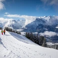
A few steps east of the Hasliberg Hohfluh PostBus stop is the starting point of the hike. From the cantonal road, a small road branches off at a right angle and leads up the slope. You gain altitude in a regular but not too steep ascent through open terrain. More and more, the view opens up to the Rosenlaui area on the opposite side of the valley.
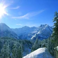
In the Bärschwendi area, the path enters the forest and runs for several hundred meters along a forest ski descent; for potential crossing situations to be recognized early and mastered safely, hikers should also exercise increased attention. In the Bannwäldli, the hiking route branches off to the left from the ski slope at point 1528. The forest opens into the vast and winter-silent high moor of the Balisalp. Above it, to the southwest, you can see the peaks of the Schwarzhorn area between Axalp and Grindelwald.
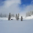
Past numerous Alpine huts, some of which are also used as holiday homes in winter, you gradually enter the ski area. The winter hiking trail initially bypasses the slopes widely, then crosses a ski lift trail and climbs immediately next to the ski slope to Käserstatt. From here, the easily walkable "Murmeliweg" continues through Chüemad towards Mägisalp in winter (however, the marmots hibernate during the cold season and are therefore not visible). Due to the magnificent view of the entire Hasli valley down to Lake Brienz, this is probably the most attractive section of the entire hike. However, the route partially runs through a heavily used ski area here – attention and mutual consideration are necessary. At the first huts of the Mägisalp in the Undere Stafel, the winter hiking trail branches off sharply to the right towards Bidmi and descends gently down the valley.
The much-visited "ski bunny land" in the Bidmi area (ski school and restaurants) soon comes into view on the left. In the wide left curve towards Bidmi, the route turns right at Halmersmad. On a quiet plateau, the path runs along the cross-country ski track to Lischen (there is a stop for the Twing-Käserstatt gondola here, providing the option to shorten the descent). Then it goes downhill, first along the ski slope, later on a small road. From the first holiday homes of the village Wasserwendi in Halti, it is not far to the destination at the PostBus stop at the REKA holiday center Wasserwendi.

Good to know
Pavements
Best to visit
Directions
Equipment
Directions & Parking facilities
Additional information
Literature
License (master data)
Safety guidelines
Nearby