
- 3:30 h
- 13.87 km
- 130 m
- 270 m
- 631 m
- 779 m
- 148 m
- Start: Frutigen
- Destination: Wimmis
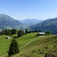
From Frutigen station downhill through the underpass to the swimming pool. Then follow the Engstlige, which flows with a steep gradient into the Kander. On the wide Kander embankment downstream. Regularly placed weirs break the force of the wild water. The shade of the floodplain forest and the coolness rising from the river are particularly pleasant on hot days. At the end of the airfield runway in Rüdle-Ey the hiking trail passes under the road and railway line and heads to the beautiful wooden houses of Rüdlen. After the covered Rüdlen bridge, follow the Kander to the valley station of the Niesenbahn. Here the Kander is crossed for the last time. The path to Wimmis continues to follow the riverbank at a short distance. Immediately you are enveloped again by the impressive silence, only broken by the rushing of the water. Below the former Heustrich spa, the path merges into the valley road. The mineral-rich sulfur spring was tapped in 1770. Around 1880, the spa, famous for relieving stomach and rheumatism ailments, enjoyed its heyday. World War I and a fire in 1932 marked its decline. A new building now serves as a home for disabled youth. From the bridge at Heustrich, follow the road, which also serves as a cycle route, but then turns at Rossweid towards the foot of the Niesen and, via Hasli, reaches the main town of the Niedersimmental, Wimmis, located on the Simme.

Good to know
Pavements
Best to visit
Directions
Frutigen - Reichenbach - Mülenen - Heustrich - Wimmis
Equipment
We recommend the following equipment: light trekking shoes, light backpack, sun protection, rain jacket, pocket pharmacy, light picnic, sufficient fluids, mobile phone.
Directions & Parking facilities
Outbound journey: by train via Spiez to Frutigen station
Return journey: by train from Wimmis station
Additional information
Berner Wanderwege Association, Bern, Tel.: 031 340 01 01, E-Mail: info@beww.ch, Homepage: www.bernerwanderwege.ch
Literature
Hiking suggestion from the hiking book Thunersee - Frutigland, hiking book series of the Berner Wanderwege
License (master data)
Safety guidelines
This route runs entirely on hiking trails.
Map
Swisstopo hiking map 1:50,000 253T Gantrisch
Nearby


")
")
")