- 4:50 h
- 12.41 km
- 850 m
- 850 m
- 1,871 m
- 2,470 m
- 599 m
- Start: Kandersteg/Sunnbüel
- Destination: Kandersteg/Sunnbüel
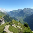
From the mountain station of the Kandersteg–Sunnbüel cable car, the path first descends into the Winteregg grazing hollow. Above the hut, you head directly towards the scree slope dominated by the Gällihorn. The trail leads through it rising downstream, then winds steeply to the ridge saddle above Gällene (to Inner Üschene 50 min; – Kandersteg/Eggeschwand 1h50). The scenery has already changed, now also opening views to the west towards Engstligengrat, Lohner group and Allmegrat. The mountain world is even more comprehensive from the nearby Gällihorn, whose summit can be reached in about half an hour's ascent. Countless peaks reach for the sky all around! At Gällene the actual high trail begins. Running almost entirely at the same height, it follows the gentler, sheep pasture and rock band-strewn western slope. Silence and solitude up here are soothing. At point 2203 you enter the narrowest part of the Üschenegrat. The cliff bands drop steeply on both sides. The deep view to the vast Spittelmatte and onto the half-forest-covered Arvenseeli is impressive. The ascent to the Wysse Flue, the highest point of this high hike, is steep. Once again, enjoy the magnificent panoramic view. The descent follows the ridge edge towards the Üschenetal.
At the Schwarzgrätli (to Tällisee 30 min; to Engstligengrat–Tschingellochtighorn and to Inner Üschene–Kandersteg/Eggeschwand 4h, for experienced hikers only; direct route to Inner Üschene–Kandersteg/Eggeschwand 2h30) you make a sharp turn east and reach a saddle in the steep scree slope, over which the path leads down to the Schwarenbach mountain hotel.
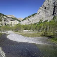
On the Gemmiweg, you now descend to point 1899 on the edge of the larch forest, where the charming little lakes lie. This short detour is worthwhile! Soon you reach the vast Spittelmatte (on the old Gemmiweg to Kandersteg/Eggeschwand 2h30). Here you turn left off the Gemmiweg and after a short ascent reach the starting point of the hike, the mountain station of the cable car at Sunnbüel.

Good to know
Pavements
Best to visit
Directions
Kandersteg/Sunnbüel - Üschenegrat - Schwarzgrätli - Schwarenbach - Kandersteg/Sunnbüel
Equipment
We recommend the following equipment: sturdy mountain boots, medium-sized backpack with hip belt, sun protection, rainwear, hiking poles, pocket first aid kit, picnic, sufficient fluids, mobile phone.
Additional information
Association Berner Wanderwege, Bern, Tel.: 031 340 01 01, E-Mail: info@beww.ch, Homepage: www.bernerwanderwege.ch
Literature
Hiking suggestion from the hiking book Berner Oberland, hiking book series of the Berner Wanderwege
License (master data)
Safety guidelines
This route runs wholly or partly on marked paths of the mountain hiking trail category.
Map
Swisstopo hiking map 1:50,000 263T Wildstrubel
Nearby