- 2:40 h
- 8.17 km
- 131 m
- 131 m
- 773 m
- 904 m
- 131 m
- Start: Frutigen
- Destination: Frutigen
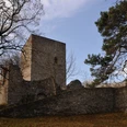
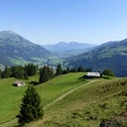
The marked path starts in the village of Frutigen on the banks of the "Engstlige", opposite the Pizzeria Falken. Follow the path towards Rohrbach to Gand, a nationally significant floodplain protection area. After about 45 minutes on flat terrain, you will reach the entirely wooden-framed granite bridge. A short climb to Bodme (about 100 meters elevation gain) opens up the view of the imposing Niesen range and the lovely Reinisch landscape. Continuing eastward, you reach the ruins of the Telleburg. The former customs station on the way to Valais now offers a beautiful view of the fascinating southern valley end with Balmhorn and Altels as well as downhill towards the hamlet of Kanderbrück and the village of Frutigen. After a short descent to Rybrügg, you pass under the large Kander viaduct. Along the Kander river, you reach the hamlet of Kanderbrück with many historic houses. Heading west, you cross the bypass road and arrive back in the village of Frutigen. Those who want to wash off their sweat can enjoy the indoor or outdoor pool of the Frutigen Sports Center after a 10-minute walk toward Spiez.

Good to know
Pavements
Best to visit
Directions
Frutigen - Granite Bridge - Tellenburg - Kanderbrück - Frutigen
Equipment
We recommend the following equipment: light trekking shoes, light backpack, sun protection, rain jacket, first aid kit, light picnic, sufficient fluids, mobile phone.
Additional information
Association Berner Wanderwege, Bern, Tel.: 031 340 01 01, E-mail: info@beww.ch, Homepage: www.bernerwanderwege.ch
License (master data)
Safety guidelines
This route runs entirely on hiking trails.
Map
Swisstopo hiking map 1:50,000 263T Wildstrubel
Nearby