


- 2:00 h
- 4.98 km
- 200 m
- 200 m
- 1,826 m
- 2,001 m
- 175 m
- Start: Betelberg/Leiterli
- Destination: Betelberg/Leiterli
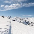
No climbing is required to reach Leiterli: The Lenk–Betelberg gondola quickly and conveniently takes you up to Betelberg, the starting point of the circular hike. The entrance to the hiking trail is located east of the mountain station building. From there, head south uphill along the slope and after 10 minutes reach the highest point of the Betelberg ski area, Leiterli. Ahead lies Stübleni, whose northern slope, the Gryde, is deeply furrowed even in winter despite the thick snow cover. Downhill the view extends to the winter-quiet Pöschenried.
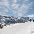
From Leiterli, descend gently in a southwesterly direction along the slope towards the Gryden. At Steinstoss, the pass-like crossing at point 1953, the Leiterli circular route turns left towards Alp Stoss, while the described Tschätte circular route continues downwards to the right.
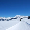
The prepared path now descends quite steeply (poles advantageous) towards Läger, makes a slight curve below the alpine hut, and then runs along the forest without significant elevation changes. A peaceful picture unfolds: above the wide plateau towers Albristhorn on the opposite side of the Simmental. Winter can be so enchanting!

Good to know
Pavements
Best to visit
Directions
Lenk/Betelberg - Leiterli - Steinstoss - Tschätte - Haslerberg - Lenk/Betelberg
Equipment
We recommend the following equipment: sturdy and waterproof hiking boots, light to medium backpack, cold protection, sun protection, hiking poles, pocket first aid kit, snacks, tea in a thermos flask, mobile phone.
Directions & Parking facilities
Additional information
Bernese Hiking Trails Association, Bern, Tel.: 031 340 01 01, E-mail: info@beww.ch, Homepage: www.bernerwanderwege.ch
Literature
Hiking suggestion from the hiking book Schneepfade in the Bernese Oberland, hiking book series of the Bernese Hiking Trails
License (master data)
Safety guidelines
This route runs on marked winter hiking trails.
Map
Swisstopo national map 1266 Lenk 1:25,000
Nearby