


- 6:00 h
- 8.28 km
- 937 m
- 937 m
- 2,079 m
- 2,929 m
- 850 m
- Start: Grindelwald, First
- Destination: First, Bergstation Gondelbahn Grindelwald-First
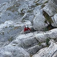
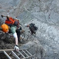
For experienced mountain walkers, the south-west ridge, visible from afar, is the optimal ascent to the highest peak in the foothills of the Alps; less experienced walkers can book this tour with a mountain guide in Grindelwald. Up to the steep ascent at Chrinneboden towards “Grossi Chrinne”, the approach follows regular trails. From the ridge, you can often see the ladders shining in the sun. The first securing elements are already available on the ascent to Grossi Chrinne. After arriving on the ridge, you climb some ladders to a less steep part of the ridge, and along this to the summit.

Jungfraubahnen Management AG
Good to know
Pavements
Path
Trail
Best to visit
suitable
Depends on weather
Directions
First - Klettersteig Schwarzhorn - First
Equipment
Sturdy hiking boots, plenty of water, sports drinks, snacks, sunscreen, cold-weather protective clothing, pocket medicine case, 1:25000 hiking map; if possible, orientation guides (GPS receiver, navigation system, altimeter), via ferrata set including helmet.
Directions & Parking facilities
Via Bern or Lucerne to Interlaken. Or from the south, via the Grimsel Pass (summer only) or the Simplon Pass and the Lötschberg car-transport train to Interlaken. Then follow the signs to Grindelwald.
In Grindelwald there are two public car parks with covered spaces to choose from: Eiger+ multi-storey car park (252 spaces) and Sportzentrum multi-storey car park (160 spaces). Uncovered parking spaces are available throughout the village.
With the Bernese Oberland Railway or by car to Grindelwald. With the First Aerial Cableway from the valley station in the upper village centre in three sections to Grindelwald-First. Journey time from Grindelwald: approximately 25 minutes.
License (master data)
Safety guidelines
Very steep climb to the ladders, long, vertical ladders, exposed.
Nearby
