


- 5:00 h
- 10.85 km
- 400 m
- 400 m
- 922 m
- 1,184 m
- 262 m
- Start: Kiental
- Destination: Kiental
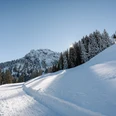
The Kiental Trail leads from Kiental via the valley station of the chairlift up to the Lengschwendi area. Along the sunny slope, you cross snowy meadows and climb up to Gürmschi. From there, it goes down into the forest to Zällergrabe/Fulbrunni. Here you have the option to return along the valley hiking trail to Kiental village (Kiental Trail blue, easy trail, 7.4 km).
Those who want can continue following the alpine path up to Tschingelsee (Kiental Trail red, medium difficulty trail, 11.4 km). The shaded, icy and snowy Tschingel area is even more impressive in winter than in summer. But don't forget warm clothes! After circumnavigating the lake, the snowshoe route follows the same way back to Zällergrabe/Fulbrunni. From here, follow the valley hiking trail (blue trail) via Losplatte back to Kiental village. Below is the elevation profile of the medium difficulty Kiental Trail (red).

Good to know
Pavements
Best to visit
Directions
Equipment
Directions & Parking facilities
Outbound and return travel: By train to Reichenbach. Then by post bus to Kiental, Ramslauenen
Additional information
License (master data)
Safety guidelines
Map
Nearby

