


- 1:40 h
- 3.95 km
- 20 m
- 500 m
- 922 m
- 1,406 m
- 484 m
- Start: Ramslauenen
- Destination: Kiental
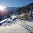
The chairlift Kiental-Ramslauenen comfortably takes you to the starting point of the snowshoe trail at the mountain station. After enjoying the magnificent view from the restaurant terrace at the mountain house, the trail first follows the toboggan run until just after the first hairpin bend. The snowshoe route then branches off to the right and descends through the Bachligrabe into the Farnital area. Over snow-covered meadows, the path leads steeply down to Lengi Weid and then towards Lengschwendi. Here you meet the Kiental Trail, which leads to Tschingelsee. A combination of the two trails is also highly recommended. With a splendid view of the village of Kiental, the path descends across open terrain. The last section to the valley station of the chairlift follows the valley hiking trail along the Chiene.

Good to know
Pavements
Best to visit
Directions
Ramslauenen – Farnital – Lengeschwendi – Valley station – Kiental
Equipment
Snowshoes, ski poles, sturdy, high, grippy and waterproof mountain or winter hiking boots, cold and sun protection, emergency first aid kit, food and warm drinks, mobile phone, possibly gaiters
Directions & Parking facilities
By car via Reichenbach to Kiental. Up to the valley station Ramslauenen railway
Starting point: Ramslauenen/mountain station by bus to Kiental/Ramslauenen, then by chairlift Kiental-Ramslauenen to the starting point
Endpoint: Ramslauenen/valley station from the valley station Kiental-Ramslauenen on foot to the Kiental/Ramslauenen bus stop, then by bus
Additional information
Berner Wanderwege, 031 340 01 01, info@beww.ch, bernerwanderwege.ch
License (master data)
Author´s Tip / Recommendation of the author
Variant: Kiental Trail
Difficulty: medium | Fitness: hard | 10.9 km | 5 h | 400 m ascent and descent
Safety guidelines
Difficulty: medium (red) / Fitness: easy
Signposting
This route is signposted as a snowshoe trail, but not specially prepared.
Avalanches
Increased avalanche danger in spring and during sudden weather changes. Helpful but not mandatory are an avalanche transceiver, probe, and shovel. Inform yourself about snow conditions and possible avalanche dangers before the tour.
Behavior
Do not take unnecessary risks and respect your limits. Always stay on the signposted routes. Avoid wildlife if possible and behave calmly. Observe animals from a distance. Pack your waste back and leave no unwanted traces.
Map
swisstopo map: 1248 Mürren, 1:25'000
Nearby

