


- 2:00 h
- 7.25 km
- 97 m
- 98 m
- 564 m
- 620 m
- 56 m
- Start: Niederried, train station
- Destination: Interlaken Ost, train station
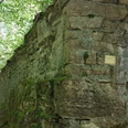
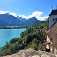
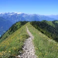
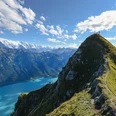
Niederried, the starting point of the hike, is easily accessible by Zentralbahn from Interlaken Ost. In summer, travel by ship is highly recommended. This way, the following hiking route can be experienced from a completely different perspective. From Niederried, the hike is continuously signposted towards Interlaken. The first part up to Ringgenberg/Säge was only added to the official hiking trail network in 2018. Past the cozy lakeside bath, shortly after the last buildings, you reach the wonderful Brätliplatz Entenstein. After a forest section, the lakeside path gently ascends, crosses the railway, and ends shortly before Ringgenberg at the main road. Follow it for 300 meters to Ringgenberg/Säge. The center of this small district is formed by a large playground framed by the arches of the distinctive railway viaduct. The viaduct is passed underneath, and the hike continues over the hidden Bühliweg path and through a beautiful forest section. Then follows a short descent down to the lake. Afterwards, a varied lakeside path section with nice places to linger leads to the Ringgenberg ship station. Just above sit the church and the ruins of Ringgenberg castle. Both buildings should definitely be visited, and you should climb the walls of the restored castle ruins. From the tower-like masonry, there is an excellent view of the enchantingly blue-green shimmering Lake Brienz. The hike then follows the path signposted as Katzenpfad to Goldswil/Katzenpfad. Here, you reach the lower end of Lake Brienz, with the Aare outflow and the railway bridge. Over the iron bridge and along the south side of the Aare, the Interlaken Ost station is reached within a few minutes. A slightly more varied route leads along the north side of the Aare to the valley station of the Harderbahn. From there, across the Aare and via the English Garden, you also reach Interlaken Ost station within a few minutes.

Good to know
Pavements
Best to visit
Directions
Niederried - Säge - Ringgenberg - Goldswil (lake) - Harderbahn - Interlaken Ost
Equipment
We recommend the following equipment: light trekking shoes, light backpack, sun protection, rain jacket, pocket first aid kit, light picnic, sufficient fluids, mobile phone.
Directions & Parking facilities
Outbound: By train or by ship via Interlaken Ost to Niederried
Return: By train from Interlaken Ost
Additional information
Bernese Hiking Trails Association, Bern, Tel.: 031 340 01 01, Email: info@beww.ch, Homepage: www.bernerwanderwege.ch
Literature
Hiking book Short hikes 2 by Bernese Hiking Trails
License (master data)
Safety guidelines
This route runs exclusively on signposted paths in the category hiking trail
Map
Swisstopo hiking map 254T Interlaken 1:50,000
Nearby


")
")
